Hochficht
| Hochficht (Smrčina) | |
|---|---|
 | |
| Highest point | |
| Elevation | 1,338 m (AA) (4,390 ft) (1,338 m n.m.) |
| Prominence | 1,338-1,018 m ↓ northwest of Studničná[1] |
| Isolation | 5.7 km → Plöckenstein |
| Coordinates | 48°44′11″N 13°55′16″E / 48.73639°N 13.92111°ECoordinates: 48°44′11″N 13°55′16″E / 48.73639°N 13.92111°E |
| Geography | |
 | |
| Location | Upper Austria, Austria and South Bohemian Region, Czech Republic |
| Parent range | Bohemian Forest |
| Geology | |
| Type of rock | Weinsberg Granite |
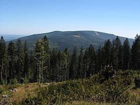
The Hochficht (Czech: Smrčina) is a mountain in the Mühlviertel in Upper Austria with a height of 1,338 m above sea level (AA). Its summit marks the border between Austria and the Czech Republic. At the top is a rock outcrop with a summit cross, a ski lift station and a weather station. The Czech side of the mountain is in the core zone of the Bohemian Forest National Park (Šumava National Park). The Hochficht in the cross-border Bohemian Forest is part of the municipality of Klaffer. The municipalities of Aigen and Ulrichsberg are also not far away and benefit from tourism with high overnighting numbers in the local inns and guest houses.
Winter sports area
The Hochficht is also a winter sports area, which covers the three adjacent mountain of Zwieselberg (1,163 m above sea level (AA)), Reischlberg (1,281 m above sea level (AA)) and Hochficht, and is open annually to the end of March or early April (usually until Easter). The start of the ski season here depends on the weather. There are 8 pistes with a total length of around 20 km and a ski route. They are served by 2 drag lifts and three 4-seater chair lifts (Hochfichtbahn since 1994[2], Schwarzenbergbahn since 2001[3], Zwieselbergbahn since 2004[4]) Since 2017 the 10-seater, 2-leg gondola lift, the Reischlbergbahn, has transported skiers up the Reischlberg.[5] The longest ski run is the Stierwiesen run from the Hochficht, the second longest is the FIS run, on which Europacup races take place. At the Zwieselberg there is also a FIS slalom run, where Europacup races also take place. The majority of pistes (55 %) are rated as easy. The valley station is at 800 m. Six langlauf routes, three of which are free, with a total length of around 165 km complete the winter sports facilities.
Hiking
In summer all the lifts are closed and there is only a small café open. Several hiking trails, including the Nordwaldkammweg from the tripoint to the Waldviertel, run over the summit; in addition there are viewing points at Stinglfelsen (1,260 m above sea level (AA)) and Schönbergfelsen (1,305 m above sea level (AA)).
Weblinks
| Wikimedia Commons has media related to Hochficht. |
References
- ↑ Prominence from viewfinderpanoramas.org (MS Excel; 89 kB)
- ↑ "Hochfichtbahn". Skiresort.de (in German). Retrieved 2017-12-28.
- ↑ "Schwarzenbergbahn". Skiresort.de (in German). Retrieved 2017-12-28.
- ↑ "Zwieselbergbahn". Skiresort.de (in German). Retrieved 2017-12-28.
- ↑ "Reischlbergbahn 1+2". Skiresort.de (in German). Retrieved 2017-12-28.