| Resource Name | Image | Address | City | Added |
| Ambler's Texaco Gas Station | 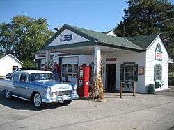 | Illinois Route 17 and Old U.S. 66
41°5′39″N 88°26′26″W / 41.09417°N 88.44056°W / 41.09417; -88.44056 (Ambler's Texaco Gas Station) | Dwight | November 29, 2001 |
| Ariston Café | 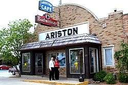 | 314 Old Route 66
39°10′38″N 89°40′5″W / 39.17722°N 89.66806°W / 39.17722; -89.66806 (Ariston Cafe) | Litchfield | May 5, 2006 |
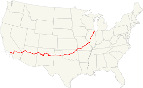
| Alternate Route 66, Wilmington to Joliet | 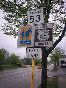 | Illinois Route 53 between Wilmington and Joliet
41°24′16″N 88°6′27″W / 41.40444°N 88.10750°W / 41.40444; -88.10750 (Alternate Route 66, Wilmington to Joilet) | Joliet and Wilmington | May 5, 2006 |
| Belvidere Café, Motel, and Gas Station | 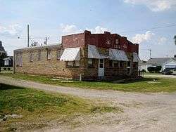 | 817 Old Route 66
39°10′16″N 89°40′3″W / 39.17111°N 89.66750°W / 39.17111; -89.66750 (Belevidere Cafe, Motel and Gas Station) | Litchfield | February 21, 2007 |
| Chain of Rocks Bridge | 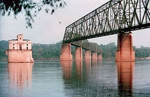 | West Chain of Rocks Rd.
38°45′41″N 90°10′26″W / 38.76139°N 90.17389°W / 38.76139; -90.17389 (Chain of Rocks Bridge) | Madison | December 01, 2006 |
| Dell Rhea's Chicken Basket |  | 645 Joliet Road
41°44′51″N 87°56′22″W / 41.74750°N 87.93944°W / 41.74750; -87.93944 (Dell Rhea's Chicken Basket) | Willowbrook | May 5, 2006 |
| Lou Mitchell's Restaurant | 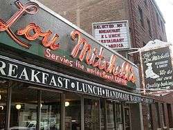 | 565 W. Jackson Blvd.
41°52′38″N 87°38′30″W / 41.87722°N 87.64167°W / 41.87722; -87.64167 (Lou Mitchell's Restaurant) | Chicago | May 5, 2006 |
| Route 66 by Carpenter Park | | Old Route 66 between Cabin Smoke Trail and north bank of the Sangamon River
39°52′21″N 89°36′51″W / 39.87250°N 89.61417°W / 39.87250; -89.61417 (Route 66 by Carpenter Park) | Springfield and Sherman | May 9, 2002 |
| Route 66, Cayuga to Chenoa | 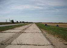 | Route 66, between just N. of Township Rd 2200 N. and just S. of Township Rd 3000 N.
40°45′12″N 88°43′7″W / 40.75333°N 88.71861°W / 40.75333; -88.71861 (Route 66, Cayuga to Chenoa) | Pontiac | July 23, 2003 |
| Route 66, Girard to Nilwood |  | Route 66, between Illinois Route 4 (IL 4) south of Girard and IL 4 in Nilwood
39°24′45″N 89°47′16″W / 39.41250°N 89.78778°W / 39.41250; -89.78778 (Route 66, Girard to Nilwood) | Nilwood | May 23, 2002 |
| Route 66, Litchfield to Mount Olive | 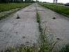 | Route 66, N of Illinois Route 16 in Litchfield to Mount Olive
39°7′48″N 89°41′34″W / 39.13000°N 89.69278°W / 39.13000; -89.69278 (Route 66, Litchfield to Mount Olive) | Litchfield | November 29, 2001 |
| Route 66 South of Lake Springfield | | Olde Rt. 66/Olde Carriage Way
39°40′30.9″N 89°37′28.92″W / 39.675250°N 89.6247000°W / 39.675250; -89.6247000 (Route 66 South of Lake Springfield) | Springfield | May 12, 2009 |
| Sprague's Super Service | 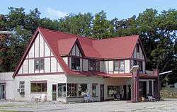 | 305 E. Pine St.
40°31′3″N 88°58′51″W / 40.51750°N 88.98083°W / 40.51750; -88.98083 (Sprague's Super Service) | Normal | April 25, 2008 |
| Standard Oil Gasoline Station | 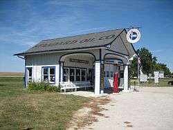 | 400 S. West St.
41°0′7″N 88°31′44″W / 41.00194°N 88.52889°W / 41.00194; -88.52889 (Standard Oil Gasoline Station) | Odell | November 9, 1997 |
| Soulsby Service Station | 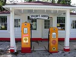 | 102 S. Route 66 St.
39°4′23″N 89°44′8″W / 39.07306°N 89.73556°W / 39.07306; -89.73556 (Soulsby Service Station) | Mount Olive | May 06, 2004 |