Hissop, Alabama
| Hissop, Alabama | |
|---|---|
| Census-designated place | |
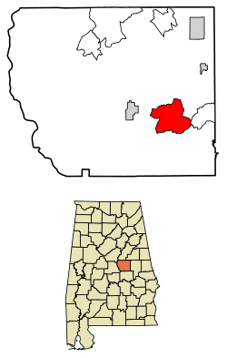 Location of Hissop in Coosa County, Alabama. | |
 Hissop Location of Hissop in Coosa County, Alabama. | |
| Coordinates: 32°53′32″N 86°09′12″W / 32.89222°N 86.15333°WCoordinates: 32°53′32″N 86°09′12″W / 32.89222°N 86.15333°W | |
| Country | United States |
| State | Alabama |
| County | Coosa |
| Area[1] | |
| • Total | 18.26 sq mi (47.30 km2) |
| • Land | 18.26 sq mi (47.28 km2) |
| • Water | 0.01 sq mi (0.02 km2) |
| Elevation | 794 ft (242 m) |
| Population (2010)[2] | |
| • Total | 552 |
| • Estimate (2016)[3] | N/A |
| Time zone | UTC-6 (Central (CST)) |
| • Summer (DST) | UTC-5 (CDT) |
| Area code(s) | 256 & 938 |
| GNIS feature ID | 120154[4] |
Hissop is a census-designated place and unincorporated community in Coosa County, Alabama, United States. Its population was 658 as of the 2010 census.[5]
Demographics
| Historical population | |||
|---|---|---|---|
| Census | Pop. | %± | |
| U.S. Decennial Census[6] | |||
History
A post office was established as Hissop in 1880, and remained in operation until it was discontinued in 1990.[7] The community was named after the biblical plant Ezov, usually translated as hyssop.[8]
References
- ↑ "2016 U.S. Gazetteer Files". United States Census Bureau. Retrieved Jul 17, 2017.
- ↑ "American FactFinder". United States Census Bureau. Retrieved 2011-05-14.
- ↑ "Population and Housing Unit Estimates". Retrieved June 9, 2017.
- ↑ "Hissop". Geographic Names Information System. United States Geological Survey.
- ↑ "Geographic Identifiers: 2010 Demographic Profile Data (G001): Hissop CDP, Alabama". U.S. Census Bureau, American Factfinder. Retrieved June 9, 2014.
- ↑ "Census of Population and Housing". Census.gov. Retrieved June 4, 2016.
- ↑ "Coosa County". Jim Forte Postal History. Retrieved 1 October 2014.
- ↑ Mann, Joel F. (1 January 2005). An International Glossary of Place Name Elements. Scarecrow Press. p. 77. ISBN 978-0-8108-5040-8.
Municipalities and communities of Coosa County, Alabama, United States | ||
|---|---|---|
| Towns | 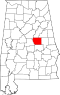 | |
| CDPs | ||
| Unincorporated communities | ||
| Footnotes | ‡This populated place also has portions in an adjacent county or counties | |
This article is issued from
Wikipedia.
The text is licensed under Creative Commons - Attribution - Sharealike.
Additional terms may apply for the media files.