Hinlopen Strait

Hinlopen Strait to the left.
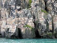
Alkefjellet cliffs in Hinlopen Strait, covered with guillemots.
Hinlopen Strait[1][2][3] (Norwegian: Hinlopenstretet) is the strait between Spitsbergen and Nordaustlandet in Svalbard, Norway. It is 150 kilometers (93 mi) long and 10 to 60 kilometers (6.2 to 37.3 mi) wide. The strait is difficult to pass because of pack ice. It is believed to have been named after Thijmen Jacobsz Hinlopen.[4]
The northern part of the strait is called Nordporten, between Storsteinhalvøya and Mosselhalvøya. The southern part, called Sørporten, widens up between Bråsvellbreen and the Bastian Islands.[5][6][7]
References
- ↑ National Geospatial-Intelligence Agency: Geographical Names.
- ↑ Vorren, Torre O., et al. 2011. Glacial History of the Barents Sea Region. In: Jurgen Ehlers, Philip Leonard Gibbard, & Philip D. Hughes (eds.), Quaternary Glaciations – Extent and Chronology: A Closer Look, pp. 361–372. Amsterdam: Elsevier, p. 369.
- ↑ Conway, Martin. 1906. No Man's Land: A History of Spitsbergen from Its Discovery in 1596 to the Beginning of the Scientific Exploration of the Country. Cambridge: Cambridge University Press, p. 360.
- ↑ Norwegian Polar Institute. "Hinlopenstretet's history". Retrieved 8 February 2009.
- ↑ "Nordporten (Svalbard)". Norwegian Polar Institute. Retrieved 20 October 2013.
- ↑ "Sørporten (Svalbard)". Norwegian Polar Institute. Retrieved 20 October 2013.
- ↑ Arctic Pilot: Sailing directions Svalbard–Jan Mayen. 7. Stavanger: The Norwegian Hydrographic Service and The Norwegian Polar Institute. 1988. p. 340. ISBN 82-90653-06-9.
External links
- http://www.caplex.no/Web/ArticleView.aspx?id=9314679 (Norwegian)
- Hinlopen Strait's wildlife
- Hinlopen Strait's geology and landscape
- Hinlopen Strait's history
- Hinlopen Strait's vegetation
Coordinates: 79°37′N 18°47′E / 79.617°N 18.783°E
This article is issued from
Wikipedia.
The text is licensed under Creative Commons - Attribution - Sharealike.
Additional terms may apply for the media files.