Hines Peak
| Hines Peak | |
|---|---|
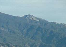 View from Santa Paula. | |
| Highest point | |
| Elevation | 6,716 ft (2,047 m) |
| Listing | Sierra Club Hundred Peaks Section[1] |
| Coordinates | 34°30′39″N 119°04′32″W / 34.510800298868°N 119.07553195953°WCoordinates: 34°30′39″N 119°04′32″W / 34.510800298868°N 119.07553195953°W |
| Geography | |
| Location | Ventura County California, U.S. |
| Parent range |
Topatopa Mountains Transverse Ranges |
| Topo map | USGS Hines Peak |
| Climbing | |
| Easiest route | Hike[1] |
Hines Peak is the highest peak of the Topatopa Mountains, at 6,716 feet (2,047 m).
It is located within the Ventura County section of Los Padres National Forest, several miles northeast of Santa Paula. Snow falls on the mountain during the winter months.
See also
| Wikimedia Commons has media related to Topatopa Mountains. |
References
- 1 2 "Hines Peak". Hundred Peaks Section List. Angeles Chapter, Sierra Club. Retrieved 2015-12-11.
This article is issued from
Wikipedia.
The text is licensed under Creative Commons - Attribution - Sharealike.
Additional terms may apply for the media files.