Himmelberg
| Himmelberg | ||
|---|---|---|
 | ||
| ||
 Himmelberg Location within Austria | ||
| Coordinates: 46°45′N 14°2′E / 46.750°N 14.033°ECoordinates: 46°45′N 14°2′E / 46.750°N 14.033°E | ||
| Country | Austria | |
| State | Carinthia | |
| District | Feldkirchen | |
| Government | ||
| • Mayor | Heimo Rinösl | |
| Area | ||
| • Total | 56.85 km2 (21.95 sq mi) | |
| Elevation | 672 m (2,205 ft) | |
| Population (1 January 2016)[1] | ||
| • Total | 2,296 | |
| • Density | 40/km2 (100/sq mi) | |
| Time zone | UTC+1 (CET) | |
| • Summer (DST) | UTC+2 (CEST) | |
| Postal code | 9562 | |
| Website | www.himmelberg.at | |

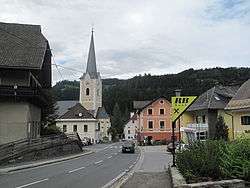
Himmelberg (Slovene: Sokolovo) is a town in the district of Feldkirchen in the Austrian state of Carinthia in Austria.
Geography
Himmelberg lies in the center of Carinthia northwest of Feldkirchen. It lies in the Tiebel valley. The highest point in the municipality is the Hoferalmkopf (el. ca. 1600 ) in the northwest. The lowest point is the Tiebel (el. 625) in the south of the municipality.
Neighboring municipalities
| Gnesau | Steuerberg | |
| Arriach |  |
|
| Steindorf | Feldkirchen in Kärnten |
References
| Wikimedia Commons has media related to Himmelberg. |
This article is issued from
Wikipedia.
The text is licensed under Creative Commons - Attribution - Sharealike.
Additional terms may apply for the media files.