Hillsboro, Georgia
| Hillsboro, Georgia | |
|---|---|
| Unincorporated community | |
 Hillsboro  Hillsboro | |
| Coordinates: 33°10′47″N 83°38′28″W / 33.17972°N 83.64111°WCoordinates: 33°10′47″N 83°38′28″W / 33.17972°N 83.64111°W | |
| Country | United States |
| State | Georgia |
| County | Jasper |
| Elevation | 646 ft (197 m) |
| Time zone | UTC-5 (Eastern (EST)) |
| • Summer (DST) | UTC-4 (EDT) |
| ZIP code | 31038 |
| Area code(s) | 706 & 762 |
| GNIS feature ID | 356309[1] |
Hillsboro is an unincorporated community in Jasper County, Georgia, United States. The community is located on Georgia State Route 11 9 miles (14 km) south of Monticello. Hillsboro has a post office with ZIP code 31038.[2][3]
It was the county seat of Baldwin County briefly in 1806 before the county was divided into Jasper and other counties.
See also
References
- ↑ "Hillsboro". Geographic Names Information System. United States Geological Survey.
- ↑ United States Postal Service. "USPS - Look Up a ZIP Code". Retrieved November 21, 2015.
- ↑ "Postmaster Finder - Post Offices by ZIP Code". United States Postal Service. Retrieved November 21, 2015.
External links
- Across the Ocmulgee historical marker
Municipalities and communities of Jasper County, Georgia, United States | ||
|---|---|---|
| City | 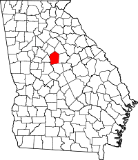 | |
| Town | ||
| Unincorporated communities | ||
This article is issued from
Wikipedia.
The text is licensed under Creative Commons - Attribution - Sharealike.
Additional terms may apply for the media files.