Hill Top, West Virginia
| Hill Top, West Virginia | |
|---|---|
| Unincorporated community | |
 Hill Top, West Virginia  Hill Top, West Virginia | |
| Coordinates: 37°27′55″N 80°54′30″W / 37.46528°N 80.90833°WCoordinates: 37°27′55″N 80°54′30″W / 37.46528°N 80.90833°W | |
| Country | United States |
| State | West Virginia |
| County | Summers |
| Elevation | 2,018 ft (615 m) |
| Time zone | UTC-5 (Eastern (EST)) |
| • Summer (DST) | UTC-4 (EDT) |
| Area code(s) | 304 & 681 |
| GNIS feature ID | 1549742[1] |
Hill Top is an unincorporated community in Summers County, West Virginia, United States, located 23 miles (37 km) south of Hinton.
A variant name was Tophet.[2]
References
- ↑ U.S. Geological Survey Geographic Names Information System: Hill Top, West Virginia
- ↑ Kenny, Hamill (1945). West Virginia Place Names: Their Origin and Meaning, Including the Nomenclature of the Streams and Mountains. Piedmont, WV: The Place Name Press. p. 629.
Municipalities and communities of Summers County, West Virginia, United States | ||
|---|---|---|
| City | 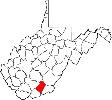 | |
| Unincorporated communities |
| |
| Ghost towns | ||
| Footnotes | ‡This populated place also has portions in an adjacent county or counties | |
This article is issued from
Wikipedia.
The text is licensed under Creative Commons - Attribution - Sharealike.
Additional terms may apply for the media files.