Heywood, Victoria
| Heywood Victoria | |||||||||
|---|---|---|---|---|---|---|---|---|---|
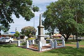 War memorial at Heywood | |||||||||
 Heywood | |||||||||
| Coordinates | 38°08′0″S 141°37′0″E / 38.13333°S 141.61667°ECoordinates: 38°08′0″S 141°37′0″E / 38.13333°S 141.61667°E | ||||||||
| Population | 1,287 (2006 census)[1] | ||||||||
| Postcode(s) | 3304 | ||||||||
| Elevation | 27 m (89 ft) | ||||||||
| Location | |||||||||
| LGA(s) | Shire of Glenelg | ||||||||
| State electorate(s) | South-West Coast | ||||||||
| Federal Division(s) | Wannon | ||||||||
| |||||||||
Heywood /ˈheɪwʊd/[2] is a town on the Fitzroy River in the Australian state of Victoria. It is situated at an elevation of 27 metres amidst rolling green hills in an agricultural, pastoral and timbercutting district. Heywood is 357 kilometres (222 mi) west of Melbourne at the intersection of the Princes and Henty Highways and 27 kilometres (17 mi) north of Portland. It is on the railway line to Portland, at the junction of the presently-unused branch to Mount Gambier, South Australia. The winner of several past “Tidy Town” awards, it is often referred to as the “Jewel Of The Southwest”
History
Prior to European settlement the area was occupied by the Gunditjmara Aborigines.[3] David Edgar built the Bush Tavern on the townsite in 1842 and a settlement emerged. Formerly known as Fitzroy Crossing it became known as Edgar's. The township was surveyed in 1852 by Lindsay Clarke who named it after Heywood, Wiltshire in England. The first town allotments were sold in 1854 and a Post Office opened on 8 August 1857.[4]
Heywood has won many Tidy Town awards.
Demographics
At the 2006 census, Heywood had a population of 1,287.[1]
Sport
The town has an Australian rules football team, the Heywood Lions, which until 2011 competed in the Western Border Football League. In 2012 it transferred to the lower grade South West District Football League. Which also created current Essendon midfielder Nathan Lovett-Murray. Golfers play at the course of the Heywood Golf Club on Golf Club Road. [5]
Climate
Heywood has a Mediterranean influenced oceanic climate with mildly warm, dry summers and cool, very wet winters.
| Climate data for Heywood | |||||||||||||
|---|---|---|---|---|---|---|---|---|---|---|---|---|---|
| Month | Jan | Feb | Mar | Apr | May | Jun | Jul | Aug | Sep | Oct | Nov | Dec | Year |
| Record high °C (°F) | 43.2 (109.8) |
43.4 (110.1) |
41.0 (105.8) |
35.0 (95) |
28.6 (83.5) |
21.1 (70) |
21.4 (70.5) |
25.8 (78.4) |
28.9 (84) |
32.8 (91) |
37.8 (100) |
42.5 (108.5) |
43.4 (110.1) |
| Average high °C (°F) | 24.4 (75.9) |
24.8 (76.6) |
23.0 (73.4) |
20.1 (68.2) |
16.9 (62.4) |
14.4 (57.9) |
13.9 (57) |
14.8 (58.6) |
16.6 (61.9) |
18.8 (65.8) |
20.5 (68.9) |
22.4 (72.3) |
19.2 (66.6) |
| Average low °C (°F) | 11.2 (52.2) |
11.8 (53.2) |
10.6 (51.1) |
8.3 (46.9) |
6.7 (44.1) |
5.0 (41) |
4.8 (40.6) |
5.2 (41.4) |
6.3 (43.3) |
7.4 (45.3) |
8.6 (47.5) |
10.1 (50.2) |
8.0 (46.4) |
| Record low °C (°F) | 0.6 (33.1) |
1.3 (34.3) |
−0.7 (30.7) |
−3.6 (25.5) |
−2.3 (27.9) |
−5.0 (23) |
−4.5 (23.9) |
−4.6 (23.7) |
−1.8 (28.8) |
−2.8 (27) |
−1.0 (30.2) |
1.0 (33.8) |
−5.0 (23) |
| Average precipitation mm (inches) | 32.9 (1.295) |
28.5 (1.122) |
40.2 (1.583) |
61.4 (2.417) |
76.8 (3.024) |
88.7 (3.492) |
99.9 (3.933) |
107.0 (4.213) |
85.4 (3.362) |
69.4 (2.732) |
59.2 (2.331) |
48.8 (1.921) |
798.3 (31.429) |
| Average precipitation days | 8.3 | 7.9 | 11.0 | 13.7 | 16.9 | 18.0 | 20.4 | 20.0 | 18.1 | 15.7 | 13.0 | 11.5 | 174.5 |
| Source: [6] | |||||||||||||
See also
References
- 1 2 Australian Bureau of Statistics (25 October 2007). "Heywood (Urban Centre/Locality)". 2006 Census QuickStats. Retrieved 1 February 2011.
- ↑ Butler, S., ed. (2009). "Heywood". Macquarie Dictionary (5th ed.). Sydney: Macquarie Dictionary Publishers Pty Ltd. 1952 pages. ISBN 978-1-876429-66-9.
- ↑ MINISTER FOR ABORIGINAL AFFAIRS - "NEW ABORIGINAL GROUP TO ADVISE ON CULTURAL HERITAGE" - Friday, 6 October 2006
- ↑ Premier Postal History, Post Office List, retrieved 2008-04-11
- ↑ Golf Select, Heywood, retrieved 2009-05-11
- ↑ "Climate statistics for". Bureau of Meteorology. Retrieved 20 January 2014.
- Learmonth, Noel F. (1970). Four Towns and a Survey. Hawthorn Press: Melbourne
External links
![]()