Hervartov
| Hervartov | |
| Village | |
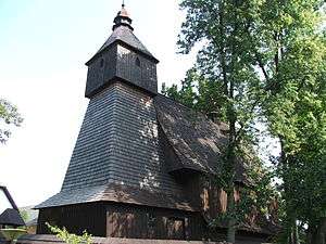 Wooden church in Hervartov | |
| Country | Slovakia |
|---|---|
| Region | Prešov |
| District | Bardejov |
| Elevation | 450 m (1,476 ft) |
| Coordinates | 49°15′N 21°12′E / 49.250°N 21.200°ECoordinates: 49°15′N 21°12′E / 49.250°N 21.200°E |
| Area | 9.87 km2 (4 sq mi) |
| Population | 507 (2004-12-31) |
| Density | 51/km2 (132/sq mi) |
| First mentioned | 1406 |
| Postal code | 086 22 |
| Area code | +421-45 |
| Car plate | BJ |
  Location of Hervartov in Slovakia | |
  Location of Hervartov in the Prešov Region | |
| Wikimedia Commons: Hervartov | |
| Statistics: MOŠ/MIS | |
| Website: www.hervartov.sk | |
Hervartov is a village and municipality in Bardejov District in the Prešov Region of north-east Slovakia.
History
In historical records the village was first mentioned in 1406. The wooden church in the village was built around 1500 and is a Roman Catholic wooden church. It has beautiful frescoes inside and due to its cultural and historical value it was declared a UNESCO World Heritage Site in 2008.[1]

Inner view of the wooden church in Hervartov
Geography
The municipality lies at an altitude of 450 metres and covers an area of 9.872 km2 (3.81 sq mi). It has a population of about 503 people.
Genealogical resources
The records for genealogical research are available at the state archive "Statny Archiv in Presov, Slovakia"
- Roman Catholic church records (births/marriages/deaths): 1749-1897 (parish B)
- Greek Catholic church records (births/marriages/deaths): 1819-1938 (parish B)
See also
References
- ↑ "Wooden Churches of the Slovak part of the Carpathian Mountain Area". UNESCO. 2008. Retrieved 2015-09-14.
External links
This article is issued from
Wikipedia.
The text is licensed under Creative Commons - Attribution - Sharealike.
Additional terms may apply for the media files.