Henry Mountains
| Henry Mountains | |
|---|---|
 Peaks in the Henry mountains viewed from a high mountain road | |
| Highest point | |
| Peak | Mount Ellen |
| Elevation | 11,522 ft (3,512 m) |
| Coordinates | 38°6.53′N 110°48.82′W / 38.10883°N 110.81367°WCoordinates: 38°6.53′N 110°48.82′W / 38.10883°N 110.81367°W |
| Geography | |
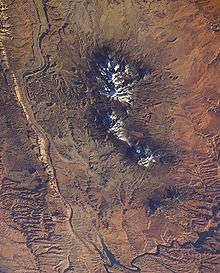
 Henry Mountains Location of the Henry Mountains within Utah | |
| Country | United States |
| State | Utah |
| Parent range | Rocky Mountains |
| Geology | |
| Type of rock | igneous |
The Henry Mountains are located in the southeastern portion of the U.S. state of Utah and run in a generally north-south direction, extending over a distance of about 30 miles (50 km). They were named by Almon Thompson in honor of Joseph Henry, the first secretary of the Smithsonian Institution. The nearest town of any size is Hanksville, Utah, which is north of the mountains. The Henry Mountains were the last mountain range to be added to the map of the 48 contiguous U.S. states (1872),[1] and before their official naming by Thompson, were sometimes referred to as the "Unknown Mountains." In Navajo, the range is still referred to as Dził Bizhiʼ Ádiní ("mountain whose name is missing").[2]
Geography and geology
The range is clustered into two main groups, with Highway 276 dividing the two portions. The northern group is by far the taller of the two with Mount Ellen: 11,522 feet above sea level; Mount Pennell: 11,371 feet; and Mount Hillers: 10,723 feet. The southern group is much lower in elevation. The southern group has two peaks: Mount Ellsworth: 8,235 feet and Mount Holmes: 8,000 feet. The southern group is also known as the "Little Rockies".
The Henry Mountains are drained by a number of canyon systems which radiate away from the isolated range, flowing north into the Fremont River, east into the Dirty Devil River, or south into Lake Powell.
The geology of these mountains was first studied in 1875-1876 by Grove Karl Gilbert.[3] He coined the term "laccolite" (now laccolith) to describe the characteristic shapes of some of the igneous intrusions that core the mountains. The main type of igneous rock is porphyritic diorite.
Ages of the igneous rocks are important for understanding the evolution of the Colorado Plateau. Ages of these rocks were reported to be about 45 to 50 million years in older geologic literature. However, it has been established that these intrusions formed in the period from about 23 to 31 million years ago, using uranium–lead dating of zircon and argon–argon dating of hornblende; fission track dating also has yielded consistent results (the older, erroneous ages were by potassium–argon dating). The intrusions are hosted by Permian to Cretaceous sedimentary rocks. The geology of these mountains is similar to the geology of the La Sal Range and of the Abajo Mountains, both also on the Colorado Plateau in southeastern Utah: locations are shown on a satellite image presented with information about the La Sal Range.
American bison
The Henry Mountains are home to approximately 350 American bison. Via genetic testing of mitochondrial and nuclear DNA, the Henry Mountains bison herd was recently shown to be one of only three free-roaming and genetically purebred bison herds on public lands in the United States.[4] This study, published in 2015, also showed the Henry Mountains bison to be free of brucellosis, a bacterial disease that was imported with non-native domestic cattle to North America.[5] The other two American herds are in Yellowstone National Park, Wind Cave National Park in South Dakota. The majority of free-ranging American Bison (approximately 90%) are found in Alberta, British Columbia, Yukon, and the Northwest Territories [6][7], with additional, recently transplanted populations in Alaska[8]
The Henry Mountains Bison Herd was created in 1941 when 18 bison, including three bulls, were moved from Yellowstone National Park and released near the Dirty Devil River, south and east of Hanksville, Utah. An additional five bulls were added to the population in 1942. The herd has gradually moved toward the Henry Mountains, frequenting elevations up to 10,000 feet. The Henry Mountain herd has been brucellosis-free since 1963.
A population objective of 325 bison by 2012 was set by Utah wildlife biologists for the Henry Mountain herd. Since the bison reproduce easily and the herds have been larger than this in the past, a decision was made to reduce the size of the herd. To achieve this objective, and increase overall genetic diversity, breeding animals are being transplanted to other locations from the herd. In January, 2009, Utah Division of Wildlife Resources officials transplanted 31 animals to the Book Cliffs in eastern Utah.[9] The new group joined 14 animals previously released in August, 2008 from a private herd on the nearby Uintah and Ouray Indian Reservation.[10] In addition, special licenses are issued annually to hunt the animals and help reduce the excess population. In 2009, 146 public once-in-a-lifetime Henry Mountain bison hunting permits were issued.[11]
Management
Much of the area is managed by the United States Bureau of Land Management.
References
- ↑ Heath, Steven H. (1997). "A Historical Sketch of the Scientific Exploration of the Region Containing the Grand Staircase-Escalante National Monument". Bureau of Land Management Science Symposium. Archived from the original on 2012-10-06. Retrieved 2009-07-05.
- ↑ Linford, L. Navajo Places. History, Legend, Landscape. University of Utah Press. 2000.
- ↑ Gilbert, Grove Karl (1880). Report on the Geology of the Henry Mountains (2 ed.). Washington, D.C.: United States Geological Survey.
- ↑ Ranglack DH, Dobson LK, du Toit JT, Derr J (December 17, 2015). "Genetic Analysis of the Henry Mountains Bison Herd". PLOS ONE. 10: e0144239. doi:10.1371/journal.pone.0144239. PMC 4682953. PMID 26673758. Retrieved December 20, 2015.
- ↑ Mary Meagher, Margaret E. Meyer (September 1994). "On the Origin of Brucellosis in Bison of Yellowstone National Park: A Review". Conservation Biology. 8: 645–653. doi:10.1046/j.1523-1739.1994.08030645.x. JSTOR 2386505.
- ↑ Ministry of Environment and Natural Resources - Northwest Territories Archived 2013-11-03 at the Wayback Machine., Ministry of Environment and Natural Resources - Northwest Territories
- ↑ Gates, Zimov, Stephenson, Chapin. "Wood Bison Recovery: Restoring Grazing Systems in Canada, Alaska and Eastern Siberia". Retrieved February 9, 2010.
- ↑ Canada Helps Restore Wood Bison to Alaska in International Conservation Effort to Recover a Threatened Species, Yahoo! Finance, July 9, 2008
- ↑ "DWR captures bison near Lake Powell". Utah Division of Wildlife Resources. Archived from the original on 2009-12-10.
- ↑ "Bison Return to the Book Cliffs". Utah Division of Wildlife Resources. Archived from the original on 2009-10-25.
- ↑ "Once-In-A-Lifetime Permits" (PDF). Utah Division of Wildlife Resources. Archived from the original (PDF) on 2010-11-11.
- Jules D. Friedman and Curtis Huffman, Jr., coordinators, Laccolith Complexes of Southeastern Utah: Time of Emplacement and Tectonic Setting—Workshop Proceedings, United States Geological Survey Bulletin 2158, 1998. http://pubs.usgs.gov/bul/b2158/B2158.pdf
- W. Kenneth Hamblin, Beyond the Visible Landscape: Aerial Panoramas of Utah's Geology. Regal Printing Limited., Hong Kong, http://www.regalprinting.com.hk 300 p., 2004. ISBN 0-9760722-0-3
- Gilbert, Grove Karl (1880). Report on the Geology of the Henry Mountains (2 ed.). Washington, D.C.: United States Geological Survey.
External links
Kay, Charles E. 2015. Long Term Vegetation Change in Utah’s Henry Mountains: A Study in Repeat Photography. BLM-UT-GI-14001-8002+REV15. 274 pages. http://www.blm.gov/style/medialib/blm/wo/blm_library/misc_pubs.Par.74891.File.dat/Kay2015_HenryMtns.pdf