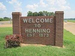
Henning, Tennessee
| Henning, Tennessee | |
|---|---|
| Town | |
 | |
 Location of Henning in Lauderdale County, Tennessee. | |
| Coordinates: 35°40′25″N 89°34′39″W / 35.67361°N 89.57750°WCoordinates: 35°40′25″N 89°34′39″W / 35.67361°N 89.57750°W | |
| Country | United States |
| State | Tennessee |
| County | Lauderdale |
| Area | |
| • Total | 1.3 sq mi (3.3 km2) |
| • Land | 1.3 sq mi (3.3 km2) |
| • Water | 0.0 sq mi (0.0 km2) |
| Elevation | 292 ft (89 m) |
| Population (2010) | |
| • Total | 945 |
| • Estimate (2016)[1] | 935 |
| • Density | 752.3/sq mi (290.5/km2) |
| Time zone | UTC-6 (Central (CST)) |
| • Summer (DST) | UTC-5 (CDT) |
| ZIP code | 38041 |
| Area code(s) | 731 |
| FIPS code | 47-33360[2] |
| GNIS feature ID | 1287426[3] |
Henning is a town in Lauderdale County, Tennessee. The population was 945 at the 2010 census.
History
The infamous Battle of Fort Pillow, a Civil War victory for the Confederates, took place near Henning. Here, nearly 200 black and white troops serving in the Union Army were killed by Confederates under the command of General Nathan Bedford Forrest.
Geography
Henning is located at 35°40′25″N 89°34′39″W / 35.67361°N 89.57750°W (35.673563, -89.577366).[4]
According to the United States Census Bureau, the town has a total area of 1.3 square miles (3.4 km2), all land.
Henning is situated on the southeastern edge of the New Madrid Seismic Zone, an area with a high earthquake risk.
Demographics
| Historical population | |||
|---|---|---|---|
| Census | Pop. | %± | |
| 1880 | 148 | — | |
| 1890 | 420 | 183.8% | |
| 1910 | 582 | — | |
| 1920 | 495 | −14.9% | |
| 1930 | 639 | 29.1% | |
| 1940 | 415 | −35.1% | |
| 1950 | 493 | 18.8% | |
| 1960 | 466 | −5.5% | |
| 1970 | 605 | 29.8% | |
| 1980 | 638 | 5.5% | |
| 1990 | 802 | 25.7% | |
| 2000 | 970 | 20.9% | |
| 2010 | 945 | −2.6% | |
| Est. 2016 | 935 | [1] | −1.1% |
| Sources:[5][6] | |||
As of the census[2] of 2000, there were 970 people, 362 households, and 238 families residing in the town. The population density was 752.3 people per square mile (290.3/km²). There were 406 housing units at an average density of 314.9 per square mile (121.5/km²). The racial makeup of the town was 22.37% White, 74.85% African American, 1.34% Native American, and 1.44% from two or more races. Hispanic or Latino of any race were 0.41% of the population.
There were 362 households out of which 32.6% had children under the age of 18 living with them, 35.4% were married couples living together, 26.0% had a female householder with no husband present, and 34.0% were non-families. 30.4% of all households were made up of individuals and 13.0% had someone living alone who was 65 years of age or older. The average household size was 2.68 and the average family size was 3.37.
In the town, the population was spread out with 32.8% under the age of 18, 10.6% from 18 to 24, 24.1% from 25 to 44, 19.2% from 45 to 64, and 13.3% who were 65 years of age or older. The median age was 31 years. For every 100 females, there were 90.9 males. For every 100 females age 18 and over, there were 76.7 males.
The median income for a household in the town was $20,438, and the median income for a family was $21,776. Males had a median income of $26,500 versus $19,583 for females. The per capita income for the town was $8,413, which is the lowest in the state. About 30.9% of families and 30.0% of the population were below the poverty line, including 31.9% of those under age 18 and 30.2% of those age 65 or over.
Government and infrastructure
The United States Postal Service operates the Henning Post Office.[7]
The Tennessee Department of Corrections operates the West Tennessee State Penitentiary in unincorporated Lauderdale County, near Henning.[8] Previously the Cold Creek Correctional Facility was located in the area.[9]
Henning is home to a community of Mississippi Band of Choctaw Indians. The tribe placed 79 acres of local land into federal trust in 2012, making it the only Native American Indian tribe that owns land in Tennessee.[10]
Education
Henning Public Schools are part of Lauderdale County School District. The School District has one primary school, two elementary schools, one middle school, one junior high school and two high schools.[11]
Shawn Kimble is the Superintendent of Schools.[12]
Notable people
- John Henry Barbee - Blues guitarist known for his connection to Chicago's blues scene
- Jim Hickman - Major League Baseball outfielder, 1962–74
- Noah Lewis - Jug band performer
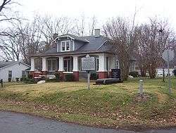
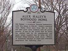
- Alex Haley - author, best known for Roots, winner of Pulitzer Prize in 1976 and acclaimed television miniseries; Henning was his boyhood home
- Ramon Foster - offensive lineman for Pittsburgh Steelers
References
| Wikimedia Commons has media related to Henning, Tennessee. |
- 1 2 "Population and Housing Unit Estimates". Retrieved June 9, 2017.
- 1 2 "American FactFinder". United States Census Bureau. Retrieved 2008-01-31.
- ↑ "US Board on Geographic Names". United States Geological Survey. 2007-10-25. Retrieved 2008-01-31.
- ↑ "US Gazetteer files: 2010, 2000, and 1990". United States Census Bureau. 2011-02-12. Retrieved 2011-04-23.
- ↑ "Census of Population and Housing: Decennial Censuses". United States Census Bureau. Archived from the original on 2006-02-08. Retrieved 2012-03-04.
- ↑ "Incorporated Places and Minor Civil Divisions Datasets: Subcounty Resident Population Estimates: April 1, 2010 to July 1, 2012". Population Estimates. U.S. Census Bureau. Archived from the original on 17 June 2013. Retrieved 11 December 2013.
- ↑ "Post Office Location - HENNING." United States Postal Service. Retrieved on September 26, 2010.
- ↑ "West Tennessee State Penitentiary." Tennessee Department of Correction. Retrieved on September 26, 2010.
- ↑ "Cold Creek Correctional Facility." Tennessee Department of Correction. February 3, 1999. Updated July 13, 1998. Retrieved on September 26, 2010.
- ↑ Vision of Trust Management Model, Responsibility and Reform, Chief Phyliss J. Anderson, Mississippi Band of Choctaw Indians, 29 April 2013, to the Secretarial Commission on Indian Trust Administration and Reform
- ↑ "Lauderdale County School District". GreatSchools Inc. Retrieved 2012-06-22.
- ↑ "Tipton County Schools". Tipton County Schools. Retrieved 2012-06-22.
Municipalities and communities of Lauderdale County, Tennessee, United States | ||
|---|---|---|
| City | ||
| Towns | ||
| Unincorporated communities | ||