Henderson, Michigan
| Henderson, Michigan | |
|---|---|
| Census-designated place | |
 Henderson, Michigan  Henderson, Michigan | |
| Coordinates: 43°05′11″N 84°11′43″W / 43.08639°N 84.19528°WCoordinates: 43°05′11″N 84°11′43″W / 43.08639°N 84.19528°W | |
| Country | United States |
| State | Michigan |
| County | Shiawassee |
| Area[1] | |
| • Total | 3.666 sq mi (9.49 km2) |
| • Land | 3.600 sq mi (9.32 km2) |
| • Water | 0.066 sq mi (0.17 km2) |
| Elevation | 732 ft (223 m) |
| Population (2010)[1] | |
| • Total | 399 |
| • Density | 110/sq mi (42/km2) |
| Time zone | UTC-5 (Eastern (EST)) |
| • Summer (DST) | UTC-4 (EDT) |
| Area code(s) | 989 |
| GNIS feature ID | 628101[2] |
Henderson is an unincorporated community and census-designated place in Rush Township, Shiawassee County, Michigan, United States. Its population was 399 as of the 2010 census.[1] The community is located along Henderson Road between North Bingham and Chipman roads. The community was named for John Henderson, who kept a store there.[3]
Geography
According to the U.S. Census Bureau, the community has an area of 3.666 square miles (9.49 km2), of which 3.600 square miles (9.32 km2) is land and 0.066 square miles (0.17 km2) is water.[1]
References
- 1 2 3 4 "2010 Census Gazetteer Files - Places: Michigan". U.S. Census Bureau. Retrieved May 6, 2018.
- ↑ "Henderson". Geographic Names Information System. United States Geological Survey.
- ↑ "Ghost towns and post offices of Shiawassee County". The Argus-Press. September 15, 2000. p. 3. Retrieved 30 April 2015.
Municipalities and communities of Shiawassee County, Michigan, United States | ||
|---|---|---|
| Cities | 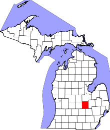 | |
| Villages | ||
| Charter townships | ||
| General law townships | ||
| Unincorporated communities | ||
| Footnotes | ‡This populated place also has portions in an adjacent county | |
This article is issued from
Wikipedia.
The text is licensed under Creative Commons - Attribution - Sharealike.
Additional terms may apply for the media files.