Helmbach (Speyerbach)
| Helmbach | |
|---|---|
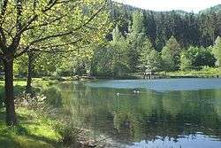 The Helmbachweiher | |
| Location | Palatine Forest, Rhineland-Palatinate, Germany |
| Reference no. | DE: 23782 |
| Physical characteristics | |
| Main source |
near Forsthaus Taubensuhl ca. 394 m above sea level (NN) [1] 49°17′40″N 7°54′05″E / 49.2943500°N 7.9012806°ECoordinates: 49°17′40″N 7°54′05″E / 49.2943500°N 7.9012806°E |
| River mouth |
Near Helmbach into the Speyerbach ca. 201 m above sea level (NN) [1] 49°20′36″N 7°59′09″E / 49.3432000°N 7.9858167°E |
| Length | 11.05 km [2] |
| Basin features | |
| Progression | Speyerbach→ Rhine→ North Sea |
| Basin size | 53.569 km² [2] |
| Landmarks | Large towns: Exclave of Landau in der Pfalz |
| Tributaries |
|
The Helmbach is an 11 km long tributary of the Speyerbach stream in the Palatine Forest in the German state of Rhineland-Palatinate.
Course
The stream rises northwest of the Taubensuhl Forester's Lodge (Forsthauses Taubensuhl) and flows initially 4 km in a northeasterly direction to the Geiswiese meadow. There it is joined on the left by the Blattbach, which rises on the north slopes of the 551 m above NN high Blattberg hill, and then heads in an easterly to northeasterly direction. After another 2 km the Helmbach passes the woodland hotel at Hornesselwiese, which was burnt down in November 2002 and, after being rebuilt in 2010, has been opened again as a woodland restaurant since January 2011 .[3] There the stream is joined by the Grobsbach and, 2.5 km further on, the Iggelbach empties into it from the left. After a total of 10 km the Helmbach reaches another forester's lodge, the Forsthaus Helmbach. Here it is joined on the right by the Kohlbach, which has been impounded to create the reservoir of Helmbachweiher a little to the east. The Helmbach itself discharges into the Speyerbach at the eponymous village of Helmbach after about etwa 11 km. Here there is a halt on the Kuckucksbähnel heritage railway.
Tributaries
- Trockendeichbach (left), 1.49 km
- Blattbach (left), 3.06 km
- Grobsbach (right), 4.35 km
- Hunzelbach (right), 1.51 km
- Frechenbach (right), 0.62 km
- Iggelbach (left), 5.08 km
- Kohlbach (right), 4.98 km
References
- 1 2 Topografische Karte 1:25.000
- 1 2 Wasserwirtschaftsverwaltung Rheinland
- ↑ Allgemeine Hotel- und Gastronomie-Zeitung, Ausgabe 2011/08 (2011-02-19). "Neuanfang nach knapp neun Jahren". p. 26. Retrieved 2011-04-11.