Helmand River
| Helmand River | |
|---|---|
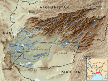 Map of the Helmand River drainage basin | |
 Map of the Helmand River drainage basin | |
| Physical characteristics | |
| Main source | Hindu Kush mountains |
| River mouth | Lake Hamun |
| Length | 1,150 km (710 mi) |
| Basin features | |
| Basin size | Sistan Basin |
| Tributaries |
|
The Helmand River (also spelled Helmend, or Helmund, Hirmand; Pashto/Persian: هیرمند / هلمند; Greek: Ἐτύμανδρος (Etýmandros); Latin: Erymandrus) is the longest river in Afghanistan and the primary watershed for the endorheic Sistan Basin.[1]
Etymology
The name comes from the Avestan Haētumant, literally "dammed, having a dam", which referred to the Helmand River and the irrigated areas around it.[2] The name was borrowed into Greek and Latin as a compound with Eastern Iranian *raha (cf. Scythian Rha "Volga"), "river".
The Helmand Province is named after the river.
Geography
The Helmand River stretches for 1,150 km (710 mi). It rises in the Hindu Kush mountains, about 80 km (50 mi) west of Kabul (34°34′N 68°33′E / 34.567°N 68.550°E), passing north of the Unai Pass, in the eastern proximities of Hazarajat, in Behsud, Maidan Wardak, flows west to Daykundi and Uruzgan. It crosses south-west through the desert of Dashti Margo, to the Seistan marshes and the Hamun-i-Helmand lake region around Zabol at the Afghan-Iranian border (31°9′N 61°33′E / 31.150°N 61.550°E).
The river remains relatively salt-free for much of its length, unlike most rivers with no outlet to the sea. This river, managed by the Helmand and Arghandab Valley Authority is used extensively for irrigation, although a buildup of mineral salts has decreased its usefulness in watering crops. Its waters are essential for farmers in Afghanistan, but it feeds into Lake Hamun and is also important to farmers in Iran's southeastern Sistan and Baluchistan province.
A number of hydroelectric dams have created artificial reservoirs on some of the Afghanistan's rivers including the Kajakai on the Helmand River. The chief tributary of the Helmand river is the Arghandab River (confluence at 31°27′N 64°23′E / 31.450°N 64.383°E) which also has a major dam north of Kandahar.
The boundaries of the province of Helmand were once known as kingdom of Sakastan.
History
Some Vedic scholars and Indologists, such as Rajesh Kochhar (1999), believe that the Helmand corresponds to the Sarasvati mentioned in the Rig Veda as the homeland for the Indo-Aryan migrations into India, circa 1500 BCE.[3]
The Helmand valley region is mentioned by name in the Avesta (Fargard 1:13) as the Aryan land of Haetumant, one of the early centers of the Zoroastrian faith in areas that are now Afghanistan. However, by the late first millennium BCE and early first millennium CE, the preponderance of non-Zoroastrian Hindus and Buddhists in the Helmand and Kabul valleys led to Parthians referring to it as White India.[4][5][6] [7] The Zunbil dynasty ruled Helmand in the mid-first millennium.
See also
Notes
- ↑ "History of Environmental Change in the Sistan Basin 1976 - 2005" (PDF). Retrieved 2007-07-20.
- ↑ Jack Finegan. Myth & Mystery: An Introduction to the Pagan Religions of the Biblical World. Baker Books, 1997. ISBN 0-8010-2160-X, 9780801021602
- ↑ Kochhar, Rajesh. 'On the identity and chronology of the Ṛgvedic river Sarasvatī' in Archaeology and Language III; Artefacts, languages and texts, Routledge (1999). ISBN 0-415-10054-2.
- ↑ http://parthia.com/doc/parthian_stations.htm
- ↑ Vendidad 1, at Avesta.org
- ↑ Beyond is Arachosia, 36 schoeni. And the Parthians call this White India; there are the city of Biyt and the city of Pharsana and the city of Chorochoad and the city of Demetrias; then Alexandropolis, the metropolis of Arachosia; it is Greek, and by it flows the river Arachotus. As far as this place the land is under the rule of the Parthians.
- ↑ Avesta, translated by James Darmesteter (From Sacred Books of the East, American Edition, 1898
References
- Various authors. "HELMAND RIVER". Encyclopædia Iranica (Online ed.). United States: Columbia University.
- Frye, Richard N. (1963). The Heritage of Persia. World Publishing company, Cleveland, Ohio. Mentor Book edition, 1966.
- Toynbee, Arnold J. (1961). Between Oxus and Jumna. London. Oxford University Press.
- Vogelsang, W. (1985). "Early historical Arachosia in South-east Afghanistan; Meeting-place between East and West." Iranica antiqua, 20 (1985), pp. 55–99.
External links
| Wikimedia Commons has media related to Helmand River. |