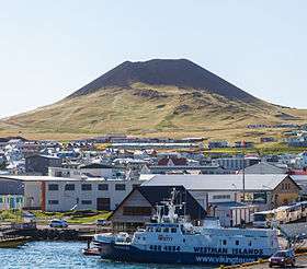
Helgafell (volcano)
| Helgafell | |
|---|---|
 | |
| Highest point | |
| Elevation | 227 m (745 ft) |
| Coordinates | 63°25′45″N 20°15′36″W / 63.42917°N 20.26000°WCoordinates: 63°25′45″N 20°15′36″W / 63.42917°N 20.26000°W |
| Geography | |
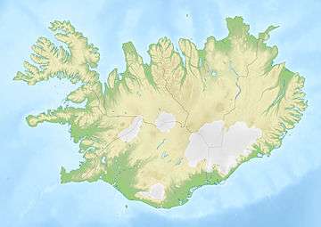 Helgafell Iceland | |
| Location | Heimaey, Iceland |
| Geology | |
| Age of rock | 5,000 years |
| Last eruption | 3950 BCE ± 300 years |
Helgafell is an inactive 227-metre-high[1] volcanic cone located on the island of Heimaey in the Vestmannaeyjar archipelago in Iceland.
The Stórhöfði peninsula immediately to the south of Helgafell in what is now southern Heimaey formed about 6000 years ago,[2] with Helgafell forming from a secondary eruption a thousand years later.[1][2] Immediately north of Helgafell is the active volcano Eldfell, which last erupted January 23, 1973.[3]
Helgafell is a dormant cone volcano. Since Eldfell, (which is a slightly shorter volcano) erupted in 1973, it's very likely that Helgafell will erupt again too.
References
- 1 2 visitvestmannislands.is
- 1 2 US Geological Survey
- ↑ Thorarinsson, S.; Steinthorsson, S.; Einarsson, T.; Kristmannsdottir, H.; Oskarsson, N. (1973-02-09). "The eruption on Heimaey, Iceland". Nature. 241 (5389): 372–375. Bibcode:1973Natur.241..372T. doi:10.1038/241372a0.
This article is issued from
Wikipedia.
The text is licensed under Creative Commons - Attribution - Sharealike.
Additional terms may apply for the media files.