Hazeldale, Oregon
| Hazeldale | |
|---|---|
| Unincorporated community | |
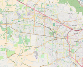
 Location of former store in Hazeldale, 2010 | |
 Hazeldale Location within Washington County, Oregon | |
| Coordinates: 45°27′59″N 122°53′35″W / 45.46639°N 122.89306°WCoordinates: 45°27′59″N 122°53′35″W / 45.46639°N 122.89306°W | |
| Country | United States |
| State | Oregon |
| County | Washington |
| Elevation | 253 ft (77 m) |
| Time zone | UTC-8 (Pacific (PST)) |
| • Summer (DST) | UTC-7 (PDT) |
| GNIS feature ID | 1136368[1] |
Hazeldale is an unincorporated community in Washington County, Oregon, United States.[2] It is located along Farmington Road south of Reedville and west of Aloha.[3]
References
- ↑ U.S. Geological Survey Geographic Names Information System: Hazeldale, Oregon
- ↑ "Hazeldale". Geographic Names Information System. United States Geological Survey. November 28, 1980. Retrieved February 21, 2016.
- ↑ Oregon Atlas & Gazetteer (7th ed.). Yarmouth, Maine: DeLorme. 2008. p. 28. ISBN 0-89933-347-8.
Municipalities and communities of Washington County, Oregon, United States | ||
|---|---|---|
| Cities | 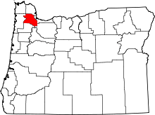 | |
| CDPs | ||
| Unincorporated communities |
| |
| Ghost towns | ||
| Footnotes | ‡This populated place also has portions in an adjacent county or counties | |
This article is issued from
Wikipedia.
The text is licensed under Creative Commons - Attribution - Sharealike.
Additional terms may apply for the media files.