Hatzerim
| Hatzerim חֲצֵרִים | |
|---|---|
 | |
 Hatzerim | |
| Coordinates: 31°14′25.44″N 34°42′50.76″E / 31.2404000°N 34.7141000°ECoordinates: 31°14′25.44″N 34°42′50.76″E / 31.2404000°N 34.7141000°E | |
| District | Southern |
| Council | Bnei Shimon |
| Affiliation | Kibbutz Movement |
| Founded | October 1946 |
| Founded by | Israeli Scouts |
| Population (2017)[1] | 808 |
| Name meaning | Farmyards |
| Website | www.hatzerim.org.il |
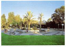
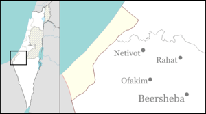
Hatzerim (Hebrew: חֲצֵרִים, lit. Farmyards) is a kibbutz located 8 kilometers west of Beersheba in the Negev desert in Israel. It is named after the Bible (Deuteronomy 2:23),[2] mentioning a site nearby: "the Avvites who lived in farmyards as far as Gaza". It belongs to the Bnei Shimon Regional Council. In 2017 it had a population of 808.
History
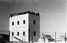
It was established in October 1946 by a young group of scouts who were then later joined by refugees from Iran, referred to as “The Children of Tehran”. They then learned agriculture and military training becoming part of the Haganah ground forces.
In the 1960s the Hatzerim Airbase was built nearby.
Netafim
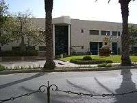
Hatzerim was one of the first kibbutzim (pl.) to break the mould from traditional agriculture and start a business. Netafim is the kibbutz business that started in 1965, that designs, manufactures and distributes irrigation systems. The business is also run with two other kibbutzim, Magal and Yiftach. There are also factories around the world, California, USA, South Africa, Western Australia and more. Netafim soon became a world leader in their field as a multinational corporation that grosses over $300 million a year.[3]
References
- ↑ "List of localities, in Alphabetical order" (PDF). Israel Central Bureau of Statistics. Retrieved August 26, 2018.
- ↑ Carta's Official Guide to Israel and Complete Gazetteer to all Sites in the Holy Land. (3rd edition 1993) Jerusalem, Carta, p.192f, ISBN 965-220-186-3 (English)
- ↑ Professor Roger Hayter. "Dynamics of Industrial Location - A Kibbutz-based MNC". Simon Fraser University (sfu.ca).
Further reading
- Gavron, Daniel. The Kibbutz: Awakening from Utopia. Lanham, MD: Rowman & Littlefield, 2000.
External links
- Kibbutz website (in Hebrew)
- Netafim Website (in English)
- Hatzerim Dance Studio and Dance Company