Hatun Suyu Q'asa
| Hatun Suyu Q'asa | |
|---|---|
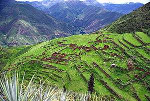 Hatun Suyu Q'asa (center) and the Willkapampa valley as seen from the archaeological site of Huch'uy Qusqu | |
| Highest point | |
| Elevation | 4,400 m (14,400 ft) [1] |
| Coordinates | 13°21′21″S 71°51′44″W / 13.35583°S 71.86222°WCoordinates: 13°21′21″S 71°51′44″W / 13.35583°S 71.86222°W [2] |
| Geography | |
 Hatun Suyu Q'asa Peru | |
| Location | Peru |
| Parent range | Andes |
Hatun Suyu Q'asa (Quechua hatun big, suyu region, q'asa mountain pass,[3] "big region pass", also spelled Jatunsuyocasa) is a mountain in the Andes of Peru, about 4,400 m (14,436 ft) high. It is located in the Cusco Region, Calca Province, on the border of the districts of Coya and Lamay. It lies southeast of Lamay between the Willkapampa valley and the Yanamayu ("black river", Yanamayo).[2][1]
References
- 1 2 escale.minedu.gob.pe - UGEL map of the Calca Province (Cusco Region)
- 1 2 "Cerro Jatunsuyocasa". IGN, Peru. Archived from the original on July 5, 2015. Retrieved July 3, 2015.
- ↑ Teofilo Laime Ajacopa, Diccionario Bilingüe Iskay simipi yuyayk'ancha, La Paz, 2007 (Quechua-Spanish dictionary)
This article is issued from
Wikipedia.
The text is licensed under Creative Commons - Attribution - Sharealike.
Additional terms may apply for the media files.