Hatogaya Station
 Hatogaya Station 鳩ヶ谷駅 | |
|---|---|
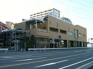 Entrance to the underground station combined with Hatogaya Civic Center, November 2007 | |
| Location |
Sato 1650-1, Kawaguchi-shi, Saitama-ken (埼玉県川口市大字里1650-1) Japan |
| Operated by |
|
| Line(s) | Saitama Rapid Railway Line |
| Platforms | 1 island platform |
| Connections |
|
| Other information | |
| Station code | SR22 |
| History | |
| Opened | 2001 |
| Traffic | |
| Passengers (FY2011) | 8,592 daily |
Hatogaya Station (鳩ヶ谷駅 Hatogaya-eki) is a railway station on the Saitama Rapid Railway Line in Kawaguchi, Saitama, Japan, operated by the third sector railway operator Saitama Railway Corporation.
Lines
Hatogaya Station is served by the 14.6 km Saitama Rapid Railway Line, which extends from Akabane-iwabuchi in Kita, Tokyo to Urawa-Misono in Midori-ku, Saitama, and lies 5.9 km from the starting point of the line at Akabane-iwabuchi.[1] The majority of services on the line continue southward onto the Tokyo Metro Namboku Line to Meguro and on the Tokyu Meguro Line to Hiyoshi in Kanagawa Prefecture.
Station layout
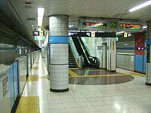
The station has an underground island platform serving two tracks. The platforms are equipped with waist-height platform edge doors.
Platforms
| 1 | ■ Saitama Rapid Railway Line | for Higashi-Kawaguchi and Urawa-Misono |
| 2 | ■ Saitama Rapid Railway Line | for Akabane-iwabuchi Tokyu Meguro Line for Hiyoshi |
Facilities and accessibility
The station concourse and platforms have elevator access. Universal access toilets are available on the concourse level.
Adjacent stations
| « | Service | » | ||
|---|---|---|---|---|
| Saitama Rapid Railway Line | ||||
| Minami-Hatogaya | - | Araijuku | ||
History
Hatogaya Station opened on 28 March 2001 with the opening of the Saitama Rapid Railway Line.[1]
Passenger statistics
In fiscal 2011, the station was used by an average of 8,592 passengers daily (boarding passengers only).[1]
Surrounding area
- National Route 122
- Saitama Prefectural Kawaguchi High School
- Saitama Prefectural Hatogaya High School
- Kawaguchi Municipal Kawaguchi Sogo High School
See also
References
External links
| Wikimedia Commons has media related to Hatogaya Station. |
- Saitama Railway station information (in Japanese)
- Saitama Prefectural Government station information (in Japanese)
Coordinates: 35°49′51″N 139°44′09″E / 35.83083°N 139.73583°E