Hatkoti
| Hatkoti | |
|---|---|
| town | |
 | |
 Hatkoti Location in Himachal Pradesh, India  Hatkoti Hatkoti (India) | |
| Coordinates: 31°07′52″N 77°44′38″E / 31.131°N 77.744°ECoordinates: 31°07′52″N 77°44′38″E / 31.131°N 77.744°E | |
| Country |
|
| State | Himachal Pradesh |
| District | Shimla |
| Elevation | 1,442 m (4,731 ft) |
| Languages | |
| • Official | Hindi |
| Time zone | UTC+5:30 (IST) |
| PIN | 171206 |
| Vehicle registration | HP-10 |
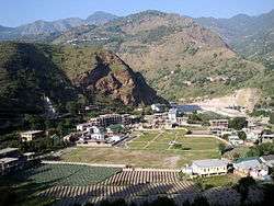
Hatkoti is a town in Shimla district in the Indian state of Himachal Pradesh. It is a town located at the banks of Pabbar River and it is about 102 kilometres away from Shimla city. Hatkoti is also famous for Hateshwari temple[1] and Sawra Kuddu Hydro Electric Project (111 MW).[2]
Geography
Hatkoti is located at 31°07′52″N 77°44′38″E / 31.131°N 77.744°E. It has an average elevation of 1,442.
Transportation
Hatkoti is well connected to Himachal and rest of India through National Highway 707 and National Highway 705.[3]
See also
Nearby Cities and Towns :-
References
- ↑ Hateswari Temple "Hateswari Temple". Department of Tourism & Civil. Retrieved 2013-04-29.
- ↑ Sawra Kuddu Hydroelectric Project "Introduction & Project Feature" (PDF). HPPCB. Retrieved 2013-04-29.
- ↑ "National Highways in Himachal Pradesh" (PDF). Himachal Pradesh Public Works Department. Retrieved 23 May 2018.
This article is issued from
Wikipedia.
The text is licensed under Creative Commons - Attribution - Sharealike.
Additional terms may apply for the media files.