Hatfield, East Riding of Yorkshire
| Hatfield | |
|---|---|
| Civil parish | |
 | |
| Population | 249 (2011 census)[1] |
| OS grid reference | TA183426 |
| Civil parish |
|
| Unitary authority | |
| Ceremonial county | |
| Region | |
| Country | England |
| Sovereign state | United Kingdom |
| Post town | HULL |
| Postcode district | HU11 |
| Dialling code | 01964 |
| Police | Humberside |
| Fire | Humberside |
| Ambulance | Yorkshire |
| EU Parliament | Yorkshire and the Humber |
| UK Parliament | |
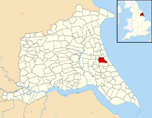
Hatfield is a civil parish in the East Riding of Yorkshire, England. It is situated 3 miles (5 km) to the south-west of Hornsea town centre and covering an area of 1,336.789 hectares (3,303.28 acres).[2]
The civil parish was formed in 1935 from the merger of the parishes of Great Hatfield, Goxhill and Little Hatfield.[3]
According to the 2011 UK census, Hatfield parish had a population of 249,[1] a decrease on the 2001 UK census figure of 258.[4]
References
- 1 2 UK Census (2011). "Local Area Report – Hatfield Parish (1170211194)". Nomis. Office for National Statistics. Retrieved 19 February 2018.
- ↑ "2001 Census Area Profile" (PDF). East Riding of Yorkshire Council. 2004. Archived (PDF) from the original on 18 March 2012. Retrieved 8 February 2013.
- ↑ "Little Hatfield CP Yorkshire through time – Administrative history of Parish-level unit: hierarchies, boundaries". A Vision of Britain through Time. University of Portsmouth & others. Retrieved 7 November 2017.
- ↑ "2001 Census: Key Statistics: Parish Headcounts: Area: Hatfield CP (Parish)". Neighbourhood Statistics. Office for National Statistics. Retrieved 12 March 2008.
- Gazetteer — A–Z of Towns Villages and Hamlets. East Riding of Yorkshire Council. 2006. pp. 6–7.
| Wikimedia Commons has media related to Hatfield. |
This article is issued from
Wikipedia.
The text is licensed under Creative Commons - Attribution - Sharealike.
Additional terms may apply for the media files.