Harrogate–Church Fenton line
| Harrogate–Church Fenton line | ||||||||||||||||||||||||||||||||||||||||||||||||||||||||||||||||||||||||||||||||||||||||||||||||||||||||||||||||||||||||||||||||||||||||||||||||||||||||||||||||||||||||||||||||||||||||||||||||||||||||||||||
|---|---|---|---|---|---|---|---|---|---|---|---|---|---|---|---|---|---|---|---|---|---|---|---|---|---|---|---|---|---|---|---|---|---|---|---|---|---|---|---|---|---|---|---|---|---|---|---|---|---|---|---|---|---|---|---|---|---|---|---|---|---|---|---|---|---|---|---|---|---|---|---|---|---|---|---|---|---|---|---|---|---|---|---|---|---|---|---|---|---|---|---|---|---|---|---|---|---|---|---|---|---|---|---|---|---|---|---|---|---|---|---|---|---|---|---|---|---|---|---|---|---|---|---|---|---|---|---|---|---|---|---|---|---|---|---|---|---|---|---|---|---|---|---|---|---|---|---|---|---|---|---|---|---|---|---|---|---|---|---|---|---|---|---|---|---|---|---|---|---|---|---|---|---|---|---|---|---|---|---|---|---|---|---|---|---|---|---|---|---|---|---|---|---|---|---|---|---|---|---|---|---|---|---|---|---|---|
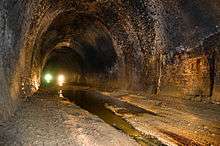 Prospect Tunnel | ||||||||||||||||||||||||||||||||||||||||||||||||||||||||||||||||||||||||||||||||||||||||||||||||||||||||||||||||||||||||||||||||||||||||||||||||||||||||||||||||||||||||||||||||||||||||||||||||||||||||||||||
| Overview | ||||||||||||||||||||||||||||||||||||||||||||||||||||||||||||||||||||||||||||||||||||||||||||||||||||||||||||||||||||||||||||||||||||||||||||||||||||||||||||||||||||||||||||||||||||||||||||||||||||||||||||||
| Type | Heavy rail | |||||||||||||||||||||||||||||||||||||||||||||||||||||||||||||||||||||||||||||||||||||||||||||||||||||||||||||||||||||||||||||||||||||||||||||||||||||||||||||||||||||||||||||||||||||||||||||||||||||||||||||
| Status | Closed from Pannal junction to Church Fenton junction | |||||||||||||||||||||||||||||||||||||||||||||||||||||||||||||||||||||||||||||||||||||||||||||||||||||||||||||||||||||||||||||||||||||||||||||||||||||||||||||||||||||||||||||||||||||||||||||||||||||||||||||
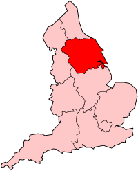
| Locale | North Yorkshire | |||||||||||||||||||||||||||||||||||||||||||||||||||||||||||||||||||||||||||||||||||||||||||||||||||||||||||||||||||||||||||||||||||||||||||||||||||||||||||||||||||||||||||||||||||||||||||||||||||||||||||||
| Termini |
Harrogate Church Fenton North Junction | |||||||||||||||||||||||||||||||||||||||||||||||||||||||||||||||||||||||||||||||||||||||||||||||||||||||||||||||||||||||||||||||||||||||||||||||||||||||||||||||||||||||||||||||||||||||||||||||||||||||||||||
| Stations | 8 | |||||||||||||||||||||||||||||||||||||||||||||||||||||||||||||||||||||||||||||||||||||||||||||||||||||||||||||||||||||||||||||||||||||||||||||||||||||||||||||||||||||||||||||||||||||||||||||||||||||||||||||
| Operation | ||||||||||||||||||||||||||||||||||||||||||||||||||||||||||||||||||||||||||||||||||||||||||||||||||||||||||||||||||||||||||||||||||||||||||||||||||||||||||||||||||||||||||||||||||||||||||||||||||||||||||||||
| Opened | 10 August 1847 | |||||||||||||||||||||||||||||||||||||||||||||||||||||||||||||||||||||||||||||||||||||||||||||||||||||||||||||||||||||||||||||||||||||||||||||||||||||||||||||||||||||||||||||||||||||||||||||||||||||||||||||
| Closed | 6 January 1964 (passengers), 30 November 1966 (goods) | |||||||||||||||||||||||||||||||||||||||||||||||||||||||||||||||||||||||||||||||||||||||||||||||||||||||||||||||||||||||||||||||||||||||||||||||||||||||||||||||||||||||||||||||||||||||||||||||||||||||||||||
| Operator(s) |
York and North Midland Railway to 1854 North Eastern Railway 1854–1923 London and North Eastern Railway 1923–1948 British Railways (N.E region) 1948 to closure | |||||||||||||||||||||||||||||||||||||||||||||||||||||||||||||||||||||||||||||||||||||||||||||||||||||||||||||||||||||||||||||||||||||||||||||||||||||||||||||||||||||||||||||||||||||||||||||||||||||||||||||
| Depot(s) | Harrogate Low (Brunswick, closed 1862)[1] | |||||||||||||||||||||||||||||||||||||||||||||||||||||||||||||||||||||||||||||||||||||||||||||||||||||||||||||||||||||||||||||||||||||||||||||||||||||||||||||||||||||||||||||||||||||||||||||||||||||||||||||
| Technical | ||||||||||||||||||||||||||||||||||||||||||||||||||||||||||||||||||||||||||||||||||||||||||||||||||||||||||||||||||||||||||||||||||||||||||||||||||||||||||||||||||||||||||||||||||||||||||||||||||||||||||||||
| Line length | 18.5 miles (29.8 km) | |||||||||||||||||||||||||||||||||||||||||||||||||||||||||||||||||||||||||||||||||||||||||||||||||||||||||||||||||||||||||||||||||||||||||||||||||||||||||||||||||||||||||||||||||||||||||||||||||||||||||||||
| Number of tracks | double | |||||||||||||||||||||||||||||||||||||||||||||||||||||||||||||||||||||||||||||||||||||||||||||||||||||||||||||||||||||||||||||||||||||||||||||||||||||||||||||||||||||||||||||||||||||||||||||||||||||||||||||
| Track gauge | 4 ft 8 1⁄2 in (1,435 mm) standard gauge | |||||||||||||||||||||||||||||||||||||||||||||||||||||||||||||||||||||||||||||||||||||||||||||||||||||||||||||||||||||||||||||||||||||||||||||||||||||||||||||||||||||||||||||||||||||||||||||||||||||||||||||
| Highest elevation | 393 ft (120 m) | |||||||||||||||||||||||||||||||||||||||||||||||||||||||||||||||||||||||||||||||||||||||||||||||||||||||||||||||||||||||||||||||||||||||||||||||||||||||||||||||||||||||||||||||||||||||||||||||||||||||||||||
| ||||||||||||||||||||||||||||||||||||||||||||||||||||||||||||||||||||||||||||||||||||||||||||||||||||||||||||||||||||||||||||||||||||||||||||||||||||||||||||||||||||||||||||||||||||||||||||||||||||||||||||||
The Harrogate–Church Fenton line was a railway line opened by the York and North Midland Railway between 1847 and 1848 linking Harrogate and Church Fenton.
History
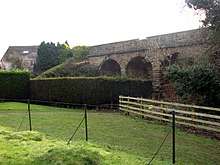
The Harrogate–Church Fenton line is a former railway line in North Yorkshire, which ran from Harrogate to Church Fenton.[2] It was staked out by York and North Midland Railway in September 1845 and the line opened from Church Fenton to Spofforth on 10 August 1847.[3] The line from Spofforth and Harrogate was opened on 20 July 1848[4] after the major engineering structures on the line (the 31-arch, 624 yards (571 m) Crimple Viaduct and the 825-yard (754 m) Prospect Tunnel) were completed.[5]
A short lived station named Crimple, located on the junction with the Leeds–Harrogate line immediately east of the viaduct, only appeared in timetables from 1867 to 1869 and has been demolished.[6]
In 1901, a new south-to-west curve was built at Wetherby to enable trains from Harrogate to Wetherby to use the Cross Gates–Wetherby line without reversal.[7] Following this, a new passenger station serving Wetherby was opened on the Cross Gates–Wetherby line and the Wetherby station on the Harrogate–Church Fenton line became goods-only.[8]
In April 1942, the Thorp Arch circular railway was opened to serve Thorp Arch Royal Ordnance Factory, which produced munitions. Trains accessed this single-track railway from the Harrogate–Church Fenton line near Thorp Arch station.[9] The ROF at Thorp Arch closed in 1958 and the circular railway was closed and lifted in the same year.[10]
Stutton station closed to passengers on 1 July 1905 but remained open for goods until the end of July 1964.[11]
The whole of the line was closed to passengers in January 1964 (one of the first of Dr Beeching's casualties)[7] and closed entirely in 1966.[12]
Harrogate Brunswick
The original terminus of the line was at Harrogate Brunswick. This left the present line just north of Hornbeam Park railway station and headed westwards through a 400-yard (370 m) tunnel (known as Brunswick Tunnel) and exited at the site of the Leeds Road and Park Drive Roundabout. It then went through a cutting before terminating at Brunswick Station.[13]
The railway was made to go through a tunnel rather than across 'The Stray' as the townsfolk were worried about the railway lowering the aristocratic tones of the spa town.[14] The station was in operation from 1848-1862 and was replaced when the North Eastern Railway built a station on the site of what is the modern day Harrogate railway station.[15]
During the Second World War, Brunswick Tunnel was used as an air raid shelter.[16]
The line today
A very short stretch of the original line (2-mile (3.2 km)) is still in use as part of the Harrogate line with services to and from Leeds.[17] Whilst the southern portal of the tunnel is still visible, all traces of the station site at Brunswick have been removed.[18]
In 1992, a 3-mile (4.8 km) stretch of the former trackbed between Spofforth and Wetherby was converted into a cycle track.[12] By 2003, the path had been extended to Thorp Arch and also included the former triangle of lines at Wetherby to link in with other cycle paths to Linton and Collingham on the West Yorkshire Cycle Route.[19]
References
- ↑ Catford, Nick. "Harrogate Brunswick". Disused Stations. Retrieved 3 October 2016.
- ↑ Bertram, D. (February 1961). "The lines to Wetherby and their traffic". Trains Illustrated. pp. 99–106.
- ↑ Rogers, J. (2000). "The railways of Harrogate and district". North East Railway Association.
- ↑ Burgess, Neil (2014). "Church Fenton - Harrogate". The lost railways of Yorkshire's West Riding: Harrogate and the north. Catrine: Stenlake Publishing. p. 8. ISBN 978-1-84033-655-9.
- ↑ "Prospect Tunnel". Forgotten relics of an enterprising age. Retrieved 3 October 2016.
- ↑ Catford, Nick (17 May 2017). "Crimple". Disused Stations. Retrieved 1 September 2017.
- 1 2 Holland, Julian (2013). "Northern England". Dr Beeching's Axe 50 Years On: Memories of Britain's Lost Railways. Newton Abbot: David & Charles. p. 135. ISBN 9781446302675.
- ↑ Catford, Nick. "Wetherby Station 2nd site". Disused Stations. Retrieved 3 October 2016.
- ↑ 28 Days Later. Map of Royal Ordnance Factory No8., . Retrieved 20 February 2012.
- ↑ Young, Alan (2015). Lost stations of Yorkshire; the West Riding. Kettering: Silver Link Publishing. p. 26. ISBN 978-1-85794-438-9.
- ↑ Catford, Nick. "Stutton Station". Disused Stations. Retrieved 3 October 2016.
- 1 2 Suggitt 2005, p. 26.
- ↑ Davison, Phill (8 February 2008). "The Harrogate Underground". BBC York & North Yorkshire. Retrieved 3 October 2016.
- ↑ "Light at the end of the abandoned tunnel". Harrogate Advertiser. 7 February 2008. Retrieved 3 October 2016.
- ↑ Suggitt 2005, p. 23.
- ↑ "Harrogate Brunswick Tunnel". Forgotten relics of an enterprising age. Retrieved 3 October 2016.
- ↑ Jacobs, Gerald (2006). Railway track diagrams book 2: Eastern. Bradford-on-Avon: Trackmaps. p. 42D. ISBN 0-9549866-2-8.
- ↑ Historic England. "TADCASTER BRANCH RAILWAY (53043)". PastScape. Retrieved 3 October 2016.
- ↑ "Wetherby Railway Path" (PDF). Leeds City Council. Retrieved 4 October 2016.
Bibliography
- Suggitt, Gordon (2005). Lost Railways of North & East Yorkshire. Countryside Books. ISBN 978-1-85306-918-5.
| Wikimedia Commons has media related to Harrogate to Church Fenton Line. |