Harrat Khaybar
| Harrat Khaybar حرة خيبر | |
|---|---|
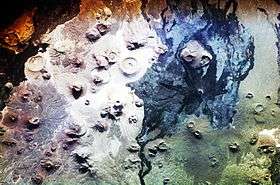 Harrat Khaybar seen from the International Space Station (North to the right of the picture) | |
| Highest point | |
| Elevation | 2,093 m (6,867 ft) |
| Coordinates | 25°43′10″N 39°56′34″E / 25.71944°N 39.94278°ECoordinates: 25°43′10″N 39°56′34″E / 25.71944°N 39.94278°E |
| Geography | |
 Harrat Khaybar حرة خيبر | |
| Geology | |
| Mountain type | Volcanic field |
| Last eruption | 650 CE ± 50 years |
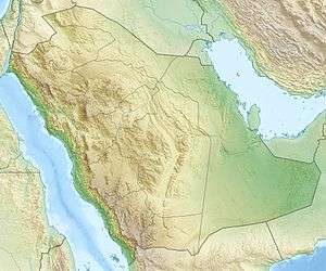
Harrat Khaybar is a volcanic field located north of Medina in Saudi Arabia. It covers approximately 12,000 km2. The most recent eruption occurred between 600 and 700 CE.
Researchers using satellite imagery have discovered evidence of man-made structures (for example, 25°40′38″N 39°57′52″E / 25.67722°N 39.96444°E) which may date from 7,000 years ago or earlier in the lava fields.[1]
See also
Sources
- ↑ Sean Martin (October 18, 2017). "GATES TO HELL? Hundreds of ancient structures found on edge of VOLCANOES in Saudi Arabia". Daily Express. Retrieved October 18, 2017.
- "Harrat Khaybar". Global Volcanism Program. Smithsonian Institution.
- "Harrat Khybar". NASA. Retrieved 20 May 2013.
This article is issued from
Wikipedia.
The text is licensed under Creative Commons - Attribution - Sharealike.
Additional terms may apply for the media files.