Harich, Friesland
| Harich | |
|---|---|
| Village | |
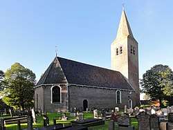 Harich church | |
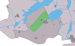 Location in the former Gaasterlân Sleat municipality | |
 Harich Location in the Netherlands | |
| Coordinates: Coordinates: 52°54′10″N 5°33′58″E / 52.90278°N 5.56611°E | |
| Country |
|
| Province |
|
| Municipality |
|
| Population (2017) | |
| • Total | 470 |
| Time zone | UTC+1 (CET) |
| • Summer (DST) | UTC+2 (CEST) |
| Postal code | 8571 |
| Telephone area | 0514 |
Harich is a small village in De Fryske Marren municipality in the province of Friesland, the Netherlands. It had a population of around 470 in 2017.[1]
History
Before 2014, Harich was part of the Gaasterlân-Sleat municipality and before 1984 it belonged to Gaasterland.
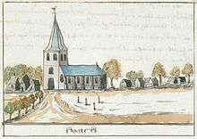
An illustration depicting the village c. 1710-1735, from the Atlas Schoemaker, currently held at the Koninklijke Bibliotheek
References
External links
![]()
This article is issued from
Wikipedia.
The text is licensed under Creative Commons - Attribution - Sharealike.
Additional terms may apply for the media files.