Hardknott Pass
| Hardknott Pass | |
|---|---|
_-_geograph.org.uk_-_546597.jpg) Hardknott Pass from Hardknott Roman Fort | |
| Elevation | 393 m (1,289 ft) [1] |
| Traversed by | Eskdale - Duddon road |
| Location | Lake District National Park, Cumbria |
| Range | Cumbrian Mountains |
| Coordinates | 54°24′10″N 3°11′50″W / 54.40269°N 3.197118°WCoordinates: 54°24′10″N 3°11′50″W / 54.40269°N 3.197118°W |
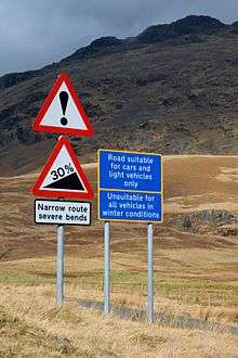
Hardknott Pass is a hill pass that carries a minor road between Eskdale and the Duddon Valley in the Lake District National Park, Cumbria, England. The tarmacked highway, which is the most direct route from the central Lake District to West Cumbria, shares the title of steepest road in England with Rosedale Chimney Bank in North Yorkshire. It has a maximum gradient of 1 in 3 (about 33%).
Etymology
The pass takes its name from Hard Knott which is derived from the Old Norse harthr (hard) and knutr (craggy hill).[2]
Geography
A single track road highway runs between Eskdale in the west to the edge of the neighbouring Wrynose Pass in the east.[3] On the western side is Harter Fell and the remains of Hardknott Roman Fort (200 metres (660 ft) above sea level).
The Hardknott Pass stands at a maximum elevation of 393 m (1,289 ft).[1] The Isle of Man in the Irish Sea can be seen on clear days.[4] The road descends steeply at a gradient of 30% (1 in 3) into the Duddon Valley.[5] At the eastern end of the pass is Cockley Beck farmhouse, it was built in the 1860s and currently owned by the National Trust. The route from Hardknott leads eastward towards the Wrynose Pass and Ambleside.[6][3]
The pass is described as one of the most challenging roads in Britain.[6] A series of hairpin bends make visibility difficult in various places.[7] Traffic ascending the pass has priority as advised by the Highway Code. The pass is often closed in winter due to ice that makes the route impassable for vehicles.[8][9] The challenging 1 in 3 gradients make the route popular with cyclists.[10] It is part of the annual Fred Whitton Challenge, a 112-mile ride around the Lake District.[11]
History
A road over the pass was built by the Romans around AD 110 to link the coastal fort and baths at Ravenglass with their garrisons at Ambleside and Kendal.[4][12] The Romans called this road the Tenth Highway.[13] The road fell into disrepair after the Romans left Britain in the early 5th century, although it remained as an unpaved packhorse route thereafter.[13] The road was originally used entirely for military traffic, but following the Romans' retreat from Britain was used to transport lead and agricultural goods.[12] By the early Middle Ages, the road was known as the Waingate ("cart road") or Wainscarth ("cart pass"): there is an 1138 record of a party of monks traversing it in an oxcart.[14] Hardknott pass and its surrounding area fell with in the domain of the Lords of Millom, being situated between the headwaters of the Esk and Duddon. Grazing and hunting rights were given to the monks of Furness Abbey by the Lords of Millom in the 13th century, which they held until the Dissolution of the Monasteries (1536-41).
In the 1880s an association of hoteliers, the English Lake District Association, financed improvements to the road in the hope of encouraging tourist excursions by carriage; by 1891 the scheme was judged to be "not the success that was anticipated".[15] Nevertheless, the route had some popularity with cyclists and early motorists, with the Cyclists' Touring Club 1911 Guide to North-West England describing the old coach road as "difficult going West, cruel coming East".[16] The first motor vehicles were taken over the Hardknott and Wrynose passes, from the Eskdale side, in 1913.[17]
In 1936, the Cumberland Highways Committee considered, and rejected, a proposal to make the pass more accessible to motors by laying down a new road surface and making other improvements. However, during the Second World War the War Office used the area for tank training completely destroying the existing road surface. After the war the wartime damage was repaired and tarmacked. A decade after the local government had rejected opening the highway to vehicles, the war's legacy had inadvertently created a direct motor route between Ambleside and Eskdale for the first time.
The courses of the Roman and modern roads are not identical. The Roman highway – on the western side – is to the north of the modern road and to the south on the eastern side of the pass.[13]
See also
References
| Wikimedia Commons has media related to Hardknott Pass. |
- Citations
- 1 2 "Spot height Ordnance Survey". Ordnance Survey. Retrieved 22 August 2015.
- ↑ Dickins (1950). The Place-names of Cumberland: Eskdale, Cumberland and Leath Wards. p. 343.
- 1 2 Corfield 2010, p. 13.
- 1 2 "Doing it the Hard(knott) way". BBC News. 10 September 2004. Retrieved 12 May 2015.
- ↑ "Britain's top 10 toughest cycle climbs". The Guardian. 20 July 2012. Retrieved 12 May 2015.
- 1 2 "In praise of Britain's two most outrageous roads – Wrynose and Hardknott passes". The Guardian. 15 July 2014. Retrieved 12 May 2015.
- ↑ Corfield 2010, pp. 13,15.
- ↑ "Police advise driving safely after cold spell". ITV News. 23 February 2015. Retrieved 12 May 2015.
- ↑ "Motorists warned to drive safely as cold snap continues in Cumbria". Westmorland Gazette. 23 February 2015. Retrieved 12 May 2015.
- ↑ "How to ride faster up short, steep hills". Cycling weekly. 17 November 2014. Retrieved 12 May 2015.
- ↑ "The six best cycling sportives of 2015". The Daily Telegraph. 7 January 2015. Retrieved 12 May 2015.
- 1 2 Brown 2010, p. 290.
- 1 2 3 Kirkup 2011, p. 64.
- ↑ The Countryman, v.51-52 (1950), 309
- ↑ Marshall and Walton, The Lake Counties from 1830 to the Mid-twentieth Century, 1981, p.195
- ↑ CTC Guide, 1911, p.116
- ↑ "Over the worst hills in England", Autocar, 12 July 1913, 49-53
Sources
- Brown, Jules (2010). The Rough Guide to the Lake District. Rough Guides UK. ISBN 978-1-848-36698-5.
- Corfield, David (2010). Roads with a View: England's Greatest Views and How to Find Them by Road. Veloce Publishing Ltd. ISBN 978-1-845-84350-2.
- Kirkup, Rob (2011). Ghostly Cumbria. The History Press. ISBN 978-0-750-95989-6.