Hampden, Alabama
| Hampden, Alabama | |
|---|---|
| Unincorporated community | |
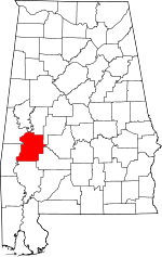
 Hampden, Alabama Location within the state of Alabama  Hampden, Alabama Hampden, Alabama (the US) | |
| Coordinates: 32°4′53.51″N 87°37′44″W / 32.0815306°N 87.62889°W | |
| Country | United States |
| State | Alabama |
| County | Marengo |
| Elevation | 197 ft (60 m) |
| Time zone | UTC-6 (Central (CST)) |
| • Summer (DST) | UTC-5 (CDT) |
| Area code(s) | 334 |
Hampden is an unincorporated community in Marengo County, Alabama, United States.[1] Hampden had a post office at one time, but it no longer exists.[2]
Demographics
| Historical population | |||
|---|---|---|---|
| Census | Pop. | %± | |
| 1870 | 40 | — | |
| U.S. Decennial Census[3] | |||
Hampden appeared on the 1870 U.S. Census as having 40 residents.[4] Of those 40, 36 (90%) were black and 4 (10%) were white. This was the only time it was listed on the census.
Geography
Hampden is located at 32°04′54″N 87°37′44″W / 32.08153°N 87.62889°WCoordinates: 32°04′54″N 87°37′44″W / 32.08153°N 87.62889°W and has an elevation of 197 feet (60 m).[1]
References
- 1 2 U.S. Geological Survey Geographic Names Information System: Hampden, Alabama
- ↑ U.S. Geological Survey Geographic Names Information System: Hampden Post Office (historical)
- ↑ "U.S. Decennial Census". Census.gov. Retrieved June 6, 2013.
- ↑ http://www2.census.gov/prod2/decennial/documents/1870a-05.pdf
This article is issued from
Wikipedia.
The text is licensed under Creative Commons - Attribution - Sharealike.
Additional terms may apply for the media files.