Hammar Marshes
| UNESCO World Heritage site | |
|---|---|
| Part of | Ahwar of Southern Iraq |
| Criteria | Mixed: (iii)(v)(ix)(x) |
| Reference | 1481-003 |
| Inscription | 2016 (40th Session) |
| Area | 20,342 ha (78.54 sq mi) |
| Buffer zone | 12,721 ha (49.12 sq mi) |
| Coordinates | 30°44′21″N 47°26′19″E / 30.73917°N 47.43861°E |
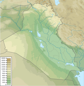 Location of Hammar Marshes in Iraq | |
| UNESCO World Heritage site | |
|---|---|
| Part of | Ahwar of Southern Iraq |
| Criteria | Mixed: (iii)(v)(ix)(x) |
| Reference | 1481-004 |
| Inscription | 2016 (40th Session) |
| Area | 79,991 ha (308.85 sq mi) |
| Buffer zone | 68,403 ha (264.11 sq mi) |
| Coordinates | 30°50′30″N 46°41′03″E / 30.84167°N 46.68417°E |
|
Location of Hammar Marshes in Iraq | |
| Designations | |
|---|---|
| Official name | Hammar Marsh |
| Designated | 7 April 2014 |
| Reference no. | 2242[1] |
The Hammar Marshes (Arabic: هور الحمار) are a large complex of wetlands in Iraq that are part of the Tigris-Euphrates river system, along with the Mesopotamian Marshes which also encompass the Hawizeh and Central Marshes. The Hammar Marshes formerly covered an area of 2,800 square kilometres of permanent wetland, extending to over 4,500 square kilometres in certain seasons, but were almost totally destroyed during the 1990s by drainage projects, and have only recently seen some recovery.
Characteristics
The Hammar Marshes stretched between Nasiriyah and Basra and were located south of the Euphrates River, which formed their principal source. Their main feature was the large brackish lake Haur al-Hammar, the largest water body in the lower Euphrates.[2] Additional water from the Tigris reached the system through overflow from the Central Marshes.
With a wide variety of habitats, the Hammar Marshes and the Haur al-Hammar supported large populations of birds, notably pelicans and ducks, with the Haur Aluwez in the south-east being especially significant for these species.[3]
The area was formerly populated by the Marsh Arabs or Ma'dan.
Draining
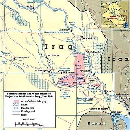
During the late 1970s, it was reported that some draining of the marshes was taking place; parts of the Haur Aluwez had been closed off by embankments and drained in order to facilitate oil exploration.[4] Subsequently, much of the northern and western end of the Haur al-Hammar was drained for development of the West Qurnah Oilfield. In the Iran–Iraq War, the southern part of the Haur al-Hammar was connected to the Al-Basrah Canal and thence to the Persian Gulf, directly increasing the salinity of the wetlands.[4]
The greatest damage occurred in the early 1990s, when the Saddam Hussein government of Iraq undertook a series of major destructive drainage projects, at least partly in reprisal for the 1991 uprisings. Reports suggested that the flow of the Euphrates had been diverted into the Third River, a huge drainage canal.[3] By 2002, the Hammar Marshes and the Haur al-Hammar had entirely disappeared.
Partial recovery
Following the 2003 U.S. invasion of Iraq, embankments and drainage works were broken open, and the marshes began to reflood. By the following year there was a significant regrowth of vegetation in the western part of the Hammar Marshes, and refilling of the eastern parts.[5] Recovery of the marshland habitat has been significantly greater than expected, though there are still long-term risks to the habitat's viability due to pollution and water extraction from the Euphrates.
References
- ↑ "Hammar Marsh". Ramsar Sites Information Service. Retrieved 25 April 2018.
- ↑ The Physical Characteristics of the Mesopotamian Marshlands, edenagain.org
- 1 2 Haur al-Hammar, birdlife.org
- 1 2 Scott, D. A Directory of Wetlands in the Middle East, earthscape.org
- ↑ Iraq Marshlands Restoration Program, iraqmarshes.org
External links
- Hawr al-Hammar Gallery, edenagain.org
Coordinates: 30°50′40″N 46°53′20″E / 30.84444°N 46.88889°E