Hamersley Range
| Hamersley Range | |
|---|---|
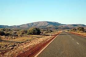 Outside the town of Paraburdoo, showing part of the Hamersley Range in the background | |
| Highest point | |
| Peak | Mount Meharry |
| Elevation | 1,249 m (4,098 ft) |
| Coordinates | 22°58′S 118°35′E / 22.967°S 118.583°E |
| Geography | |
 | |
| Country | Australia |
| State | Western Australia |
| Region | Pilbara |
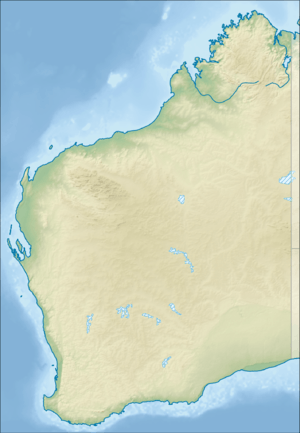
| Range coordinates | 21°53′S 116°46′E / 21.883°S 116.767°ECoordinates: 21°53′S 116°46′E / 21.883°S 116.767°E |

The Hamersley Range is a mountainous region of the Pilbara, Western Australia. The range was named on 12 June 1861 by explorer F.T. Gregory after Edward Hamersley, a prominent promoter of his exploration expedition to the Northwest.[1]
The range runs from the Fortescue River in the northeast, 460 km to the south. The range contains Western Australia's highest point, Mount Meharry, which reaches approximately 1,249 metres (4,098 ft) AHD. There are many extensively eroded gorges, such as Wittenoom Gorge. The twenty highest peaks in Western Australia are in the Hamersley Range.[2] Peaks in the range include Mount Bruce (1,234 metres (4,049 ft)), Mount Nameless (1,115 metres (3,658 ft)), Mount Reeder Nichols (1,109 metres (3,638 ft)), Mount Samson (1,107 metres (3,632 ft)), Mount Truchanas (1,148 metres (3,766 ft)) and Mount Tom Price (775 metres (2,543 ft)).[3]
Karijini National Park (formerly Hamersley National Park), one of Australia's largest National Parks, is centred in the range.

The range contains large deposits of iron ore, producing a large proportion of Australia's iron ore exports. It is predominately associated with Banded Iron Formation (BIF).[4][5][6]
Western Australia's major iron producers have mines, communities and railways that occur along the range[7] Rio Tinto operates several iron ore mines within the range including Mt. Tom Price, Marandoo, Brockman, Channar, West Angelas, Mesa A mine, and Paraburdoo. Over 100 million tonnes of iron ore is removed from the range every year.[8]
In 1999 a small range within the Hamersley was named the Hancock Range after the Hancock family who were pioneers in the area. The Hancock range is east of Karijini National Park in a region of broad valleys and peaks that rise to almost 1,200 metres (3,937 ft). The Hancock Range is close to Mulga Downs Station, a property owned by the Hancock family and where Lang Hancock is buried.[9]
The traditional owners of the area that the range runs through are the Yindjibarndi peoples.[10]
See also
References
- ↑ "North-Western Australia: Gregory's Expedition". Empire. Sydney, NSW. 3 January 1862. p. 2. Retrieved 2 June 2017.
- ↑ "Landgate - Interesting facts about Western Australia". 2009. Archived from the original on 2009-04-12. Retrieved 2009-04-23.
- ↑ "Bonzle Digital Atlas - Map of Mount Tom Price". 2009. Retrieved 2009-04-23.
- ↑ MacLeod, W. N. (1966) The geology and iron deposits of the Hamersley Range area. Bulletin (Geological Survey of Western Australia), No. 117
- ↑ "Geology". Rio Tinto Iron Ore. Archived from the original on 2012-10-23. Retrieved 2012-08-07.
- ↑ "Iron 2002 - Key Iron Deposits of the World - Module 1, Australia". Portergeo.com.au. 2002-09-18. Retrieved 2012-08-07.
- ↑ Iron fact sheet - Australian Resources and Deposits Archived 2011-02-18 at the Wayback Machine. Geoscience Australia website, accessed: 7 November 2010
- ↑ "Rio Tinto Iron Ore - Mining". 2010. Archived from the original on 2010-06-12. Retrieved 2010-11-06.
- ↑ "The naming of Hancock Range within Hamersley Range honours Hancock family". Government of Western Australia. 23 July 1999. Archived from the original on 4 September 2008. Retrieved 20 October 2013.
- ↑ "AusAnthrop Australian Aboriginal tribal database". 2009. Archived from the original on 2010-07-06. Retrieved 2012-05-05.
Further reading
- Marshall, Lloyd (1966) New Iron Age in the Hamersleys in the Weekend News, Sept. 3, 1966.
- Powell, C. M.; Horwitz, R. C. (1994). Late Archaean and Early Proterozoic tectonics and basin formation of the Hamersley Ranges (PDF). Geological Society of Australia (WA Division), Excursion guidebook 4. ISBN 0-909869-90-1.