Hambühren
| Hambühren | ||
|---|---|---|
| ||
 Hambühren Location of Hambühren within Celle district 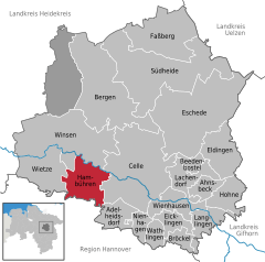  | ||
| Coordinates: 52°38′0″N 09°59′0″E / 52.63333°N 9.98333°ECoordinates: 52°38′0″N 09°59′0″E / 52.63333°N 9.98333°E | ||
| Country | Germany | |
| State | Lower Saxony | |
| District | Celle | |
| Government | ||
| • Mayor | Thomas Herbst | |
| Area | ||
| • Total | 56.7 km2 (21.9 sq mi) | |
| Elevation | 36 m (118 ft) | |
| Population (2017-12-31)[1] | ||
| • Total | 10,185 | |
| • Density | 180/km2 (470/sq mi) | |
| Time zone | CET/CEST (UTC+1/+2) | |
| Postal codes | 29313 | |
| Dialling codes | 05084, 05143 (Oldau) | |
| Vehicle registration | CE | |
| Website | www.hambuehren.de | |

Hambühren is a municipality in the district of Celle, in Lower Saxony, Germany. It is situated approximately 7 km (4.3 mi) west of Celle.
History
From the summer of 1944 to February 1945, a satellite camp of Bergen-Belsen concentration camp was in operation at Hambühren. Guarded by SS staff, around 400 female prisoners were forced to expand the former potash mine and to lay train tracks to it, work carried out by the company Hochtief. The tunnels were intended as an underground production site for Bremen plane manufacturer Focke-Wulf.[2]:204
Towns and municipalities in Celle (district) | ||
|---|---|---|
References
- ↑ Landesamt für Statistik Niedersachsen, Tabelle 12411: Fortschreibung des Bevölkerungsstandes, Stand 31. Dezember 2017
- ↑ Knoch, Habbo (ed) (2010). Bergen-Belsen: Wehrmacht POW Camp 1940–1945, Concentration Camp 1943–1945, Displaced Persons Camp 1945–1950. Catalogue of the permanent exhibition. Wallstein. ISBN 978-3-8353-0794-0.
This article is issued from
Wikipedia.
The text is licensed under Creative Commons - Attribution - Sharealike.
Additional terms may apply for the media files.