Hajhir Mountains
| Mashanig | |
|---|---|
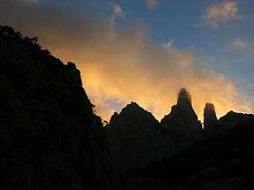 The twin peaks of Mashanig. The fallen pillar bridging the peaks is called "Mishifo". The left-hand tower is the ultra-high point of the range. | |
| Highest point | |
| Elevation | 1,503[1] m (4,931 ft) |
| Coordinates | 12°34′57″N 54°02′24″E / 12.582376°N 54.039919°ECoordinates: 12°34′57″N 54°02′24″E / 12.582376°N 54.039919°E |
| Geography | |
 Mashanig Soqotra | |
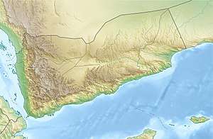
| Location | Soqotra, Yemen and Somalia |
| Parent range | Hajhir Mountains |
| Climbing | |
| First ascent | Unknown. Possibly a Soqotri goatherd. |
The Hajhir massif is a mountain range situated on the island of Socotra, Yemen. It is the highest point of the island.
Geography
The granite spires of the Hajhir massif are located in the hinterland of Soqotra and are most easily accessed via the valley approaches north of the coastal town of Hadibo. The ultra-high point of the range is the high peak of Mashanig which lies at approximately 1500m above sea level. Other peaks of local prominence include Girhimitin, Hazrat Muqadriyoun and Herem Hajhir.
Etymology
The name "Hajhir" (Soqotri: هجهر), sometimes transliterated as "Hagghier" or "Hagher" in English,[2] likely derives from the Arabic "hijr" (Arabic: حجر) meaning "stone". Other possible origins of the range's name include the word "hajar" (Arabic: هجر) meaning "to flee".
The name "Mashanig" (Soqotri: مشنغ), meaning "the split one", likely derives from the Arabic verb "inshaq" (Arabic: انشق) meaning "to split", from which one gets the word "munshuq" (Arabic: منشق) meaning "splittist".
Climbing history
Bedouin goatherds have a long history of climbing in the Hajhir. A 2014 study of Soqotri oral storytelling traditions revealed that a number of popular myths recount ascents throughout the range by local goatherds. According to the anthropologist Christopher Elliott, many accounts demonstrate a strong oral chain of transmission that links mythical characters with actual pre-modern ascents[3].
Approximate coordinates
12°33′09″N 53°59′46″E – 12°31′45″N 54°03′41″E – 12°34′37″N 54°07′43″E – 12°36′50″N 54°04′06″E, highest peak Scant: 1526 m a.s.l.