HMS K4
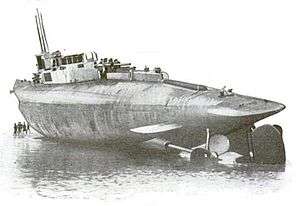 HMS K4 beached on Walney Island | |
| History | |
|---|---|
| Name: | HMS K4 |
| Builder: | Vickers, Barrow-in-Furness |
| Laid down: | 28 June 1915 |
| Commissioned: | 1 January 1917 |
| Fate: | Sunk, 31 January 1918 |
| General characteristics | |
| Class and type: | K-class submarine |
| Displacement: |
|
| Length: | 339 ft (103 m) |
| Beam: | 26 ft 6 in (8.08 m) |
| Draught: | 20 ft 11 in (6.38 m) |
| Propulsion: |
|
| Speed: |
|
| Range: |
|
| Complement: | 59 (6 officers and 53 ratings) |
| Armament: |
|
HMS K4 was a British K-class submarine built by Vickers in Barrow-in-Furness. She was laid down on 28 June 1915 and commissioned on 1 January 1917, one year before the end of World War I.
Accident 17 November 1917
On 17 November 1917, K4 collided with sister ship K1 during an accident off the Danish coast. The light cruiser Blonde operating with K1 had to make a sharp turn to avoid three units from the 4th Cruiser Squadron. And in the confusion, K4 collided with K1. The crew of K1 were rescued and K1 sunk by the Blonde.
Loss
K4 was lost on 31 January 1918 during the night time fleet exercises later known as the Battle of May Island (Operation E.C.1) when she was attached to the 13th Submarine Flotilla. While attempting to avoid a collision with K3, she became the victim of collisions with K6 and K7. She was lost with all hands. The wreck is designated as a protected place under the Protection of Military Remains Act 1986.[1]
References
Publications
- Colledge, J. J.; Warlow, Ben (2006) [1969]. Ships of the Royal Navy: The Complete Record of all Fighting Ships of the Royal Navy (Rev. ed.). London: Chatham Publishing. ISBN 978-1-86176-281-8. OCLC 67375475.
- Hutchinson, Robert (2005). Janes Submarines: War Beneath The Waves, from 1776 to the Present Day. HarperCollins. ISBN 0060819006.
External links
| Shipwrecks |
|
|---|---|
| Other incidents |
|
1916 October 1917 | |
| Shipwrecks |
|
|---|---|
| Other incidents |
|
1917 December 1917 | |