Hüfingen
| Hüfingen | ||
|---|---|---|
| ||
 Hüfingen Location of Hüfingen within Schwarzwald-Baar-Kreis district 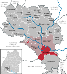  | ||
| Coordinates: 47°55′34″N 08°29′24″E / 47.92611°N 8.49000°ECoordinates: 47°55′34″N 08°29′24″E / 47.92611°N 8.49000°E | ||
| Country | Germany | |
| State | Baden-Württemberg | |
| Admin. region | Freiburg | |
| District | Schwarzwald-Baar-Kreis | |
| Government | ||
| • Mayor | Michael Kollmeier (CDU) | |
| Area | ||
| • Total | 58.53 km2 (22.60 sq mi) | |
| Elevation | 684 m (2,244 ft) | |
| Population (2017-12-31)[1] | ||
| • Total | 7,703 | |
| • Density | 130/km2 (340/sq mi) | |
| Time zone | CET/CEST (UTC+1/+2) | |
| Postal codes | 78183 | |
| Dialling codes | 0771 | |
| Vehicle registration | VS | |
| Website | www.huefingen.de | |

Hüfingen is a town in the district of Schwarzwald-Baar, in Baden-Württemberg, Germany. It is situated on the Breg River, 4 km south of the source of the Danube.
History
Hüfingen has the historical distinction of once marking the boundary of the Roman empire. In the first century of the common era, imperial policy settled on using the natural boundaries formed by the Danube and the Rhine rivers. Because of its proximity to the source of the Danube in nearby Donaueschingen, Hüfingen was the site of a Roman fort, Brigobanne, built to implement this policy. The legions built a road to Hüfingen from what is now Schleitheim, on the upper Rhine in Switzerland, thus connecting the two rivers with a man-made line on the landscape, defining a continuous border.[2]
Geography
Location
The city is situated at around 750 meters above sea level on the Baar plateau on the eastern edge of the southern Black Forest in the valley of Breg, about four kilometers south of Donaueschingen.
Nearby towns
To the north of the town is Donaueschingen, to the east is the city Geisingen in the district of Tuttlingen, to the south the town borders on Blumberg, and to the west is the city of Bräunlingen.
References
- ↑ "Bevölkerung nach Nationalität und Geschlecht am 31. Dezember 2017". Statistisches Landesamt Baden-Württemberg (in German). 2018.
- ↑ pp 29, 30 August Vetter "Geisingen: Eine Stadtgrundung der Edelfreien fon Wartenberg" copyright 1964 Sudkurier GmbH Konstanz.
External links
| Authority control |
|---|