Höchstädt im Fichtelgebirge
| Höchstädt i.Fichtelgebirge | ||
|---|---|---|
| ||
 Höchstädt i.Fichtelgebirge Location of Höchstädt i.Fichtelgebirge within Wunsiedel im Fichtelgebirge district 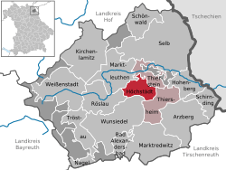 | ||
| Coordinates: 50°06′N 12°05′E / 50.100°N 12.083°ECoordinates: 50°06′N 12°05′E / 50.100°N 12.083°E | ||
| Country | Germany | |
| State | Bavaria | |
| Admin. region | Oberfranken | |
| District | Wunsiedel im Fichtelgebirge | |
| Municipal assoc. | Thiersheim | |
| Government | ||
| • Mayor | Rudolf Reichel (CSU) | |
| Area | ||
| • Total | 14.95 km2 (5.77 sq mi) | |
| Elevation | 565 m (1,854 ft) | |
| Population (2017-12-31)[1] | ||
| • Total | 1,110 | |
| • Density | 74/km2 (190/sq mi) | |
| Time zone | CET/CEST (UTC+1/+2) | |
| Postal codes | 95186 | |
| Dialling codes | 09235 | |
| Vehicle registration | WUN | |
| Website | www.95186-hoechstaedt.de | |

Höchstädt im Fichtelgebirge is a municipality in the district of Wunsiedel in Bavaria in Germany.
References
- ↑ "Fortschreibung des Bevölkerungsstandes". Bayerisches Landesamt für Statistik und Datenverarbeitung (in German). September 2018.
Towns and municipalities in Wunsiedel (district) | ||
|---|---|---|
This article is issued from
Wikipedia.
The text is licensed under Creative Commons - Attribution - Sharealike.
Additional terms may apply for the media files.