Gyhum
| Gyhum | ||
|---|---|---|
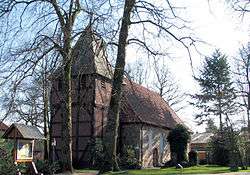 Saint Margaret Lutheran church | ||
| ||
 Gyhum Location of Gyhum within Rotenburg (Wümme) district 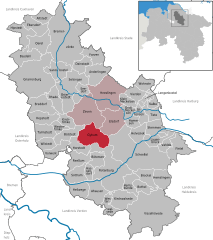  | ||
| Coordinates: 53°13′00″N 09°19′08″E / 53.21667°N 9.31889°ECoordinates: 53°13′00″N 09°19′08″E / 53.21667°N 9.31889°E | ||
| Country | Germany | |
| State | Lower Saxony | |
| District | Rotenburg (Wümme) | |
| Municipal assoc. | Zeven | |
| Government | ||
| • Mayor | Friedhelm Helberg (SPD) | |
| Area | ||
| • Total | 48.44 km2 (18.70 sq mi) | |
| Elevation | 28 m (92 ft) | |
| Population (2017-12-31)[1] | ||
| • Total | 2,328 | |
| • Density | 48/km2 (120/sq mi) | |
| Time zone | CET/CEST (UTC+1/+2) | |
| Postal codes | 27404 | |
| Dialling codes | 04286 | |
| Vehicle registration | ROW | |
| Website | www.gyhum.de | |

Gyhum is a municipality in the district of Rotenburg, in Lower Saxony, Germany.
Gyhum belonged to the Prince-Archbishopric of Bremen. In 1648 the Prince-Archbishopric was transformed into the Duchy of Bremen, which was first ruled in personal union by the Swedish and from 1715 on by the Hanoverian Crown. In 1823 the Duchy was abolished and its territory became part of the Stade Region.
References
This article is issued from
Wikipedia.
The text is licensed under Creative Commons - Attribution - Sharealike.
Additional terms may apply for the media files.