Gustavo A. Madero, Mexico City
| Gustavo A. Madero | |
|---|---|
| Delegación | |
 | |
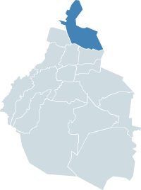 Gustavo A. Madero within the Federal District | |
| Coordinates: 19°28′56″N 99°06′45″W / 19.48222°N 99.11250°WCoordinates: 19°28′56″N 99°06′45″W / 19.48222°N 99.11250°W | |
| Country | Mexico |
| Federal entity | D.F. |
| Established | 1931 |
| Named for | Gustavo A. Madero |
| Seat | Calle 5 de Febrero esq. Vicente Villada, Col. Villa Gustavo A. Madero, C.P. 07050 |
| Government | |
| • Jefe delegacional | Nora Arias Salinas (PRD) |
| Area[1] | |
| • Total | 88.09 km2 (34.01 sq mi) |
| Elevation[1] | 2,243 m (7,359 ft) |
| Population 2010 [2] | |
| • Total | 1,185,772 |
| • Density | 13,000/km2 (35,000/sq mi) |
| Time zone | UTC-6 (Central Standard Time) |
| • Summer (DST) | UTC-5 (Central Daylight Time) |
| Postal codes | 07000 – 07990 |
| Area code(s) | 55 |
| Website | http://www.gamadero.gob.mx/ |
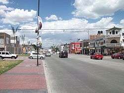
Gustavo A. Madero is one of the 16 municipalities into which Mexico City is divided.
Origins
Founded as "Villa de Guadalupe" in 1563, it became the city of "Villa de Guadalupe Hidalgo" in 1828, and finally a delegación in 1931. It was named after Gustavo A. Madero, the brother and fellow revolutionary of President Francisco I. Madero.
Points of Interest
The area houses the Basílica de Guadalupe, the shrine of Our Lady of Guadalupe at the foot of Tepeyac Hill, where Roman Catholics believe the Virgin Mary appeared to the indigenous Mexican Juan Diego Cuauhtlatoatzin in 1531.
Being the northern-most borough, the Northern Central Bus Station (Terminal Central del Norte) is located here, providing constant bus runs to all major cities in the northern and western part of the country.
On Sundays, the San Felipe de Jesús Tianguis in the neighborhood of the same name, is Latin America's largest tianguis or street market, with 30,000 vendors and stretching seven kilometers.[3][4][5]
History
The Treaty of Guadalupe Hidalgo, ending the Mexican–American War of 1846–1848 was signed in Gustavo A. Madero.
Education
Public high schools of the Instituto de Educación Media Superior del Distrito Federal (IEMS) include:[6]
- Escuela Preparatoria Gustavo A. Madero I "Belisario Domínguez"
- Escuela Preparatoria Gustavo A. Madero II "Salvador Allende"
Private schools:
- Multiple campuses of the Sistema Educativo Justo Sierra: Acueducto (Laguna Ticomán), Aragón (San Juan de Aragón), and Insurgentes (Lindavista)[7]
- Colegio Guadalupe in Lindavista[8]
- Escuela Cristóbal Colón de la Salle (three campuses)[9]
- Instituto Ovalle Monday S. C. (preschool through junior high school, including elementary schools in Lindavista)[10]
Climate
| Month | Jan | Feb | Mar | Apr | May | Jun | Jul | Aug | Sep | Oct | Nov | Dec | Year |
|---|---|---|---|---|---|---|---|---|---|---|---|---|---|
| Record high °C (°F) | 37.0 (98.6) |
31.0 (87.8) |
38.5 (101.3) |
35.0 (95) |
36.5 (97.7) |
35.0 (95) |
30.0 (86) |
29.5 (85.1) |
30.0 (86) |
30.5 (86.9) |
31.0 (87.8) |
29.0 (84.2) |
38.5 (101.3) |
| Average high °C (°F) | 22.7 (72.9) |
24.4 (75.9) |
27.0 (80.6) |
27.9 (82.2) |
27.7 (81.9) |
25.9 (78.6) |
24.4 (75.9) |
24.5 (76.1) |
23.9 (75) |
23.8 (74.8) |
23.3 (73.9) |
22.2 (72) |
24.8 (76.6) |
| Daily mean °C (°F) | 13.4 (56.1) |
14.8 (58.6) |
17.2 (63) |
18.8 (65.8) |
19.4 (66.9) |
19.1 (66.4) |
18.1 (64.6) |
18.1 (64.6) |
17.8 (64) |
16.6 (61.9) |
15.0 (59) |
13.5 (56.3) |
16.8 (62.2) |
| Average low °C (°F) | 4.1 (39.4) |
5.3 (41.5) |
7.5 (45.5) |
9.6 (49.3) |
11.1 (52) |
12.2 (54) |
11.7 (53.1) |
11.7 (53.1) |
11.6 (52.9) |
9.5 (49.1) |
6.8 (44.2) |
4.9 (40.8) |
8.8 (47.8) |
| Record low °C (°F) | −7.5 (18.5) |
−5.0 (23) |
−1.0 (30.2) |
−1.0 (30.2) |
0.9 (33.6) |
5.5 (41.9) |
6.0 (42.8) |
7.0 (44.6) |
0.0 (32) |
−5.0 (23) |
−6.5 (20.3) |
−6.0 (21.2) |
−7.5 (18.5) |
| Average precipitation mm (inches) | 8.9 (0.35) |
6.8 (0.268) |
10.2 (0.402) |
23.6 (0.929) |
48.6 (1.913) |
104.9 (4.13) |
121.2 (4.772) |
118.5 (4.665) |
98.0 (3.858) |
48.8 (1.921) |
13.4 (0.528) |
5.3 (0.209) |
608.2 (23.945) |
| Average precipitation days (≥ 0.1 mm) | 1.8 | 1.8 | 2.6 | 6.1 | 10.0 | 14.9 | 18.0 | 17.5 | 14.0 | 7.6 | 2.9 | 1.6 | 98.8 |
| Source: Servicio Meteorológico National[11] | |||||||||||||
References
- 1 2 "Delegación Gustavo A. Madero" (PDF) (in Spanish). Sistema de Información Económica, Geográfica y Estadística. Retrieved 2008-09-18.
- ↑ 2010 census tables: INEGI Archived 2013-05-02 at the Wayback Machine.
- ↑ "Los mejores tianguis para chacharear en la Ciudad". Chilango.com. 28 July 2016. Retrieved 26 July 2018.
- ↑ "Tianguis de la San Felipe: no podrás recorrerlo en un día - Máspormás". Madpormas.com. 23 January 2017. Retrieved 26 July 2018.
- ↑ "Tianguis de San Felipe de Jesús tendrá mayor seguridad". Excelsior.com.mx. 27 April 2017. Retrieved 26 July 2018.
- ↑ "Planteles Gustavo A. Madero." Instituto de Educación Media Superior del Distrito Federal. Retrieved on May 28, 2014.
- ↑ "Preparatoria - Ubicación." Sistema Educativo Justo Sierra. Retrieved on April 12, 2016. "Plantel Acueducto Av. Acueducto No. 914 Col. Laguna Ticomán, Del. Gustavo A. Madero, D.F." and "Plantel Aragón Av. José Loreto Fabela No. 460 Col. San Juan de Aragón, C. P. 07950 Delegación Gustavo A. Madero. México, D. F." and "Insurgentes Norte No. 1560 Col. Lindavista C.P. 07300 Delegación Gustavo A. Madero México D.F."
- ↑ Home page. Colegio Guadalupe. Retrieved on April 12, 2016. "Visitanos en: Managua No. 852, Col. Lindavista, Delegación Gustavo A. Madero, México, D.F, C.P. 07300"
- ↑ Home page. Escuela Cristóbal Colón de la Salle. Retrieved on April 12, 2016. "Preescolar Av. Misterios #25 Col. Tepeyac Insurgentes Del. Gustavo A. Madero C.P. 07020 Ciudad de México" and "Primaria Chulavista #43 Col. Tepeyac Insurgentes Del. Gustavo A. Madero C.P. 07020 Ciudad de México" and "Secundaria y Preparatoria Av. Miguel Bernard #52 Col. Siete Maravillas Del. Gustavo A. Madero C.P. 07320 Ciudad de México"
- ↑ "Home#Planteles." Instituto Ovalle Monday S. C. Retrieved on September 24, 2016. Preescolar and Secundaria (preschool and junior high school): "Guillermo Massieu Jelguera No. 265 Residencial La Escalera Gustavo A. Madero, México, D. F." and "Primaria Torres Lindavista Uruyen No. 38 Residencial Torres Lindavista Gustavo A. Madero, México, D. F." and "Primaria Latacunga Latacunga No. 802 Colonia Lindavista Gustavo A. Madero, México, D. F."
- ↑ "NORMALES CLIMATOLÓGICAS 1951-2010". Servicio Meteorológico National. Retrieved October 29, 2012.
External links
| Wikimedia Commons has media related to Gustavo A. Madero, Mexico City. |
- (in Spanish) Delegación Gustavo A. Madero Official site
- (in Spanish) North Bus Station Official site