Gurur

Coordinates: 12°15′04″N 76°37′45″E / 12.25111°N 76.62921°E
| Gurur, Mysore | |
|---|---|
| Coordinates: 12°15′39″N 76°38′50″E / 12.26075°N 76.64715°E | |
| Country | India |
| State | Karnataka |
Gurur is a small village in Mysore district, Karnataka, India.
Location
Gurur is located on the south of Mysore city. It is at a distance of 7.9 km from Mysore city.[1]
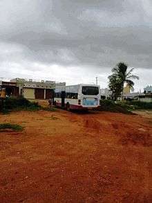
Transportation
Bus No.11-A goes to Gurur from city bus station pasing through Jayaprakash Nagar and Vidyaranyapura. The nearest railway station is Ashokapuram Mysore. Gorur has a post office and the pincode is 570008.[2]
Nearby villages
- Ramabhai Nagar
- Sidhappa complex
- Mahadevapura
- D.Block
- Gobli Mara
- Kalalavadi
- Udburu
Demographics
According to 2011 census, Gurur has a population of 2,292 people. Of this 1,171 are males and the rest are females. Children below six years make upof of 11 per cent of the total population. The literacy rate is 68 per cent.[3]
Administration
Gorur is administered by a village head called Sarpanch who is elected by the people every five years.
Major Landmarks
- S.S.E.T. National Public school, Gurur
- World Peace Centre,Institute for Indian Art and Culture, Kalalavadi
See also
Image Gallery
.jpg) Railway gate on Gurur road
Railway gate on Gurur road.jpg) Temple at Mahadevpura
Temple at Mahadevpura
References
- ↑ https://www.google.co.in/maps/dir/Mysuru,+Karnataka+570001/Gurur,+Karnataka/@12.2662602,76.6044562,13z/data=!3m1!4b1!4m13!4m12!1m5!1m1!1s0x3baf70381d572ef9:0x2b89ece8c0f8396d!2m2!1d76.6393805!2d12.2958104!1m5!1m1!1s0x3baf659961ee8d5d:0xcb6e1d06acfd9662!2m2!1d76.6268306!2d12.2367336
- ↑ http://www.onefivenine.com/india/villages/Mysore/Mysore/Gurur
- ↑ http://www.census2011.co.in/data/village/618738-gurur-karnataka.html