Gunung Padang Megalithic Site
Gunung Padang is a megalithic site located in Karyamukti village, Cianjur regency, West Java Province of Indonesia, 30 km southwest of the city of Cianjur or 6 kilometers from Lampegan station. It has been called the largest megalithic site in all of Southeastern Asia, and has produced carbon dating results which, if confirmed, suggest it is extraordinarily old.[1] The survey believes that Gunung Padang was built in four different eras.[2]
History

The existence of the site was mentioned in Rapporten van de Oudheidkundige Dienst (ROD, "Report of the Department of Antiquities") in 1914. The Dutch historian N. J. Krom also mentioned it in 1949. Employees of the National Archeology Research Centre visited the site in 1979 for a study of its archaeology, history, and geology.
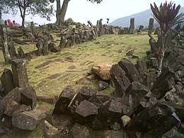
Located at 885 metres above sea level, the site covers a hill in a series of terraces bordered by retaining walls of stone that are accessed by about 400 successive andesite steps rising about 95 metres. It is covered with massive rectangular stones of volcanic origin. The Sundanese people consider the site sacred and believe it was the result of King Siliwangi's attempt to build a palace in one night. The asymmetric Punden Berundak faces northwest, to Mount Gede[3] and was constructed for the purpose of worship. Based on various dating techniques, the site was completed by 5000 BC and quite likely much earlier.[4]
The villages closest to the site are Cimanggu, Ciwangun and Cipanggulakan. Two possible routes to access the site are
- From Sukabumi to Cianjur: From Warungkondang to Cipadang, Cibokor, Lampegan Pal Dua, Ciwangin, Cimanggu.
- From Cianjur to Sukabumi: From Sukaraja to Cireungas, Cibanteng, Rawabesar, Sukamukti and Cipanggulaan.
At the end of June 2014, the Education and Culture Ministry declared Gunung Padang Megalithic Site a National Site Area of 29 hectares area.[5]
On October 1, 2014, surveyors halted excavation activities temporarily due to these facts and recommendations:[6]
- There is a large structure below the surface
- A core zone site area has been confirmed
- Many man-made artefacts have been discovered
- The construction of the site spans four eras
- A recommendation has been made to extend the survey, renovation concept, conservation and management of the site
The 2014 excavation has been criticized for being improperly conducted.[7]
2012 survey
A survey conducted in 2012 showed the following:[8][9]
- The site was dated 6,500 years BP (before present) by carbon radiometric dating at 3–4 metres below the surface (12,500 years at 8 to 10 metres below the surface), and the artifacts at the surface date to about 4,800 years BP.
- Based on geoelectric, georadar, and geomagnetic testing, at least up to 15 metres from the surface there is construction with large chambers.
- Unlike the south side with its 5 stone terraces, the east side has 100 stone terraces with width and height of 2x2 metres. The west side also has stone terraces but is still covered by soil and bush, and the north side has, in addition to a 1.5 metre-wide stair, terraces also.
- The site area is approximately 25 hectares, in contrast for example to Borobudur Temple, which occupies only 1.5 hectares.
- Wall-side construction of the terraces is similar to that of Machu Picchu in Peru.
Criticism
Thirty-four Indonesian scientists signed a petition questioning the motives and methods of the Hilman-Arif team.[1] Vulcanologist Sutikno Bronto states that the site is the neck of an ancient volcano and not a man-made pyramid.[1] An unnamed archaeologist suggests that the Hilman-Arif team has "created a civilisation around the period to explain their finding".[1]
References
- 1 2 3 4 Digging for the truth at controversial megalithic site - Michael Bachelard, Sydney Morning Herald, July 27, 2013
- ↑ Yunanto Wiji Utomo (June 6, 2014). "Mari Terbang ke Atas Situs Megalitikum Gunung Padang".
- ↑ "From Lampegan to Mount Padang". Pikiran-rakyat.com. Retrieved 2013-07-19.
- ↑ "Situs Megalitik Gunung Padang, Cianjur: Harmoni Bumi dan Langit". February 22, 2011.
- ↑ "Balai Pengelolaan Situs Gunung Padang Segera Dibentuk". June 25, 2014.
- ↑ "Timnas Gunung Padang Hentikan Penelitian". October 1, 2014.
- ↑ "Archaeologists slam excavation of Gunung Padang site". thejakartapost.com.
- ↑ "Laporan Resmi: Situs Gunung Padang Punya 100 Undakan dan Luasnya 25 Hektar". June 27, 2012.
- ↑ "Tim Terpadu Riset Mandiri: Gunung Padang Truly Extraordinary". June 28, 2012.
| Wikimedia Commons has media related to Gunung Padang Megalithic Site. |
Coordinates: 6°59′36.5″S 107°03′22.96″E / 6.993472°S 107.0563778°E