Gulmarg Gondola
Gulmarg Gondola in Gulmarg, Jammu and Kashmir is one of the world's highest operating cable cars . Higher lines include the Dagu Glacier Gondola in Sichuan, China which reaches 4843 m , Jade Dragon ( 4506 ) in Yunnan , and the Mi Teleferico between El Alto and La Paz , in Bolivia.
Background
The two-stage gondola lift ferries about 600 people per hour to and from Kongdoori Mountain, a shoulder of nearby Apharwat Peak (4,200 m (13,780 ft)). The ropeway project is a joint venture of the Jammu and Kashmir government and French firm Pomagalski. The first stage transfers from the Gulmarg resort at 2,600 m (8,530 ft) to Kongdoori Station in the bowl-shaped Kongdori valley. The second stage of the ropeway, which has 36 cabins and 18 towers, takes skiers to a height of 3,747 m (12,293 ft) on Kongdoori Mountain, a shoulder of nearby Afarwat Peak (4,200 m (13,780 ft)). The second stage was completed in a record time of about two years at a cost of 180,000,000 Indian Rupees (i.e. some US$4.5 million) and opened on 28 May 2005. The French company had also built the first phase of the gondola project, connecting Gulmarg to Kongdoori, in 1998.
The timing of the gondola is 10 AM (IST) to 5 PM (It's highly dependent upon the weather at both stages). A gondola can carry six people at a time. The price is 700 Indian Rupees (11 US$) for the first stage and 900 Indian Rupees (15 US$) for the second stage. Also offered is Chair Cars for phase-II for 300/- INR. It takes approximately 9 minutes to reach the first stage and 12 minutes for second stage.
An accident occurred on 15 June 2017 due to an enormous pine tree being uprooted by a gust of wind and breaking the perspex windows on one of the gondola cabins, causing it to swing violently and its seven occupants to fall 100 ft (30 m) to the ground.[1]
Gallery
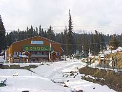
 Gulmarg gondola base station in May 2013
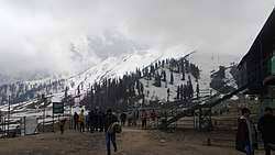 Gulmarg Kungdoor gondola station in May 2013, 2nd stage gondola and chairlift seen on right
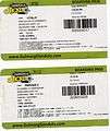 Boarding passes
References
- ↑ "Gulmarg Gondola claims 7 lives in tragic accident | K-Line Adventures". K-Line Adventures. 2017-06-26. Retrieved 2017-09-14.
External links
- Official website
- Description by Remontées Mécaniques (French)
- Article in BBC News of 26 February 2009
Coordinates: 34°02′43″N 74°23′04″E / 34.04528°N 74.38444°E