Guipronvel
| Guipronvel Gwiproñvel | ||
|---|---|---|
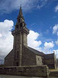 The Church of Our Lady of Good News, in Guipronvel | ||
| ||
 Guipronvel Location within Brittany region  Guipronvel | ||
| Coordinates: 48°29′28″N 4°34′23″W / 48.4911°N 4.5731°WCoordinates: 48°29′28″N 4°34′23″W / 48.4911°N 4.5731°W | ||
| Country | France | |
| Region | Brittany | |
| Department | Finistère | |
| Arrondissement | Brest | |
| Canton | Saint-Renan | |
| Area1 | 8.39 km2 (3.24 sq mi) | |
| Population (2008)2 | 705 | |
| • Density | 84/km2 (220/sq mi) | |
| Time zone | UTC+1 (CET) | |
| • Summer (DST) | UTC+2 (CEST) | |
| INSEE/Postal code | 29076 /29290 | |
| Elevation | 23–90 m (75–295 ft) | |
|
1 French Land Register data, which excludes lakes, ponds, glaciers > 1 km2 (0.386 sq mi or 247 acres) and river estuaries. 2 Population without double counting: residents of multiple communes (e.g., students and military personnel) only counted once. | ||
.svg.png)
Guipronvel (Breton: Gwiproñvel) is a former commune in the Finistère department of Brittany in north-western France. On 1 January 2017, it was merged into the new commune Milizac-Guipronvel.[1]
Population
Inhabitants of Guipronvel are called in French Guipronvélois.
| Historical population | ||
|---|---|---|
| Year | Pop. | ±% |
| 1962 | 384 | — |
| 1968 | 362 | −5.7% |
| 1975 | 385 | +6.4% |
| 1982 | 522 | +35.6% |
| 1990 | 570 | +9.2% |
| 1999 | 609 | +6.8% |
| 2008 | 705 | +15.8% |
See also
References
- ↑ Arrêté préfectoral 29 June 2016 (in French)
- Mayors of Finistère Association (in French);
External links
| Wikimedia Commons has media related to Guipronvel. |
- French Ministry of Culture list for Guipronvel (in French)
This article is issued from
Wikipedia.
The text is licensed under Creative Commons - Attribution - Sharealike.
Additional terms may apply for the media files.