Gudlavalleru mandal
| Gudlavalleru Mandal | |
|---|---|
| Mandal | |
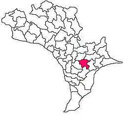 Mandal map of Krishna district showing Gudlavalleru mandal (in Rose Colour) | |
 Gudlavalleru Mandal Location in Andhra Pradesh, India  Gudlavalleru Mandal Gudlavalleru Mandal (India) | |
| Coordinates: 16°20′55″N 81°02′57″E / 16.3487°N 81.0492°ECoordinates: 16°20′55″N 81°02′57″E / 16.3487°N 81.0492°E | |
| Country | India |
| State | Andhra Pradesh |
| District | Krishna |
| Mandal | Gudlavalleru |
| Languages | |
| • Official | Telugu |
| Time zone | UTC+5:30 (IST) |
| Vehicle registration | AP 16 |
Gudlavalleru mandal is one of the 50 mandals in the Krishna district of the Indian state of Andhra Pradesh.[1]
References
- ↑ "Census 2011 Krishna district". Retrieved 6 November 2017.
This article is issued from
Wikipedia.
The text is licensed under Creative Commons - Attribution - Sharealike.
Additional terms may apply for the media files.