Guaniguanico
| Guaniguanico | |
|---|---|
| Cordillera de Guaniguanico | |
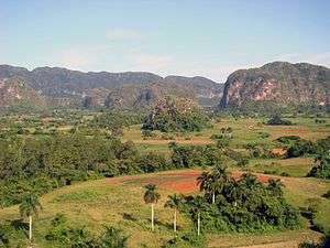 Viñales Valley, part of the cordillera | |
| Highest point | |
| Peak | Pan de Guajaibón |
| Elevation | 699 m (2,293 ft) |
| Coordinates | 22°47′26.66″N 83°21′53.03″W / 22.7907389°N 83.3647306°W |
| Dimensions | |
| Length | 160 km (99 mi) |
| Geography | |
 Location of Guaniguanico in Cuba | |
| Country | Cuba |
| Provinces | Pinar del Río and Artemisa |
| Range coordinates | 22°43′19″N 83°28′48″W / 22.72194°N 83.48000°WCoordinates: 22°43′19″N 83°28′48″W / 22.72194°N 83.48000°W |
.jpg)
Guaniguanico, also known as Cordillera de Guaniguanico, is a mountain range of western Cuba that spans from the centre-west of Pinar del Río Province to the western area of Artemisa Province.[1] It is formed by the subranges of Sierra del Rosario and Sierra de los Órganos.[2][3]
Geography
The cordillera spans for a length of circa 160 km, from the town Guane, in the west of Pinar del Río Province, to the Alturas de Mariel, near Mariel, Artemisa Province. The two subranges composing it, Sierra de los Órganos (west) and Sierra del Rosario (east), are divided in the middle by the San Diego River (Río San Diego). The highest peak is the Pan de Guajaibón (699 m), located between the municipalities of Bahía Honda and La Palma. It represents a symbol of western Cuba.[4][3][5]
Landmarks
The Guaniguanico includes the Viñales Valley,[6] a natural reserve and World Heritage Site; and other landmarks as the waterfalls of Salto de Soroa, the nature reserve of Las Terrazas, and the protected area of Mil Cumbres.[7]
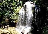 Salto de Soroa waterfall
 Las Terrazas natural reserve
See also
References
- ↑ Guaniguanico map and pictures (mapcarta.com)
- ↑ (in Spanish) Guaniguanico on EcuRed
- 1 2 Guaniguanico at Encyclopædia Britannica
- ↑ (in Spanish) Pan de Guajaibón on EcuRed
- ↑ Pan de Guajaibón (Cuba Naturaleza website)
- ↑ "Viñales National Park on the Guaniguanico Mountain Range" (Cuba Naturaleza website)
- ↑ (in Spanish) Mil Cumbres on EcuRed
External links
![]()
Mountain ranges of Cuba | |||
|---|---|---|---|