Guadalupe Reservoir
| Guadalupe Reservoir | |
|---|---|
 | |
| Location | Santa Clara County, California |
| Coordinates | 37°11′54″N 121°52′36″W / 37.19827°N 121.876659°WCoordinates: 37°11′54″N 121°52′36″W / 37.19827°N 121.876659°W |
| Type | Reservoir |
| Primary inflows | Guadalupe Creek |
| Primary outflows | Guadalupe Creek |
| Basin countries | United States |
| Max. length | 2,624 ft (800 m) |
| Max. width | 492 ft (150 m) |
| Surface area | 74 acres (300,000 m2) |
| Water volume | 3,415 acre⋅ft (4,212,000 m3) |
| Surface elevation | 618 ft (188 m) |
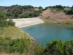
Guadalupe Reservoir is a reservoir in Santa Clara County, California, United States, about 5 miles (8 km) east of the city of San Jose, California. It is at an elevation of 614 feet (187 m).[1] It has a capacity of 3,415 acre feet (4,212,000 m3). The dam is located along Hicks Creek on Guadalupe Creek, a tributary of the Guadalupe River. The Guadalupe River was named by the de Anza expedition on March 30, 1776, Rio de Nuestra Señora de Guadalupe, in honor of the Mexican saint who was the principal patron saint of the expedition. Guadalupe dam and reservoir is one of the six original systems approved for construction by voters in 1934, and was constructed in 1935. The surface area of the reservoir is 74 acres (300,000 m2).
The California Office of Environmental Health Hazard Assessment (OEHHA) has developed a safe eating advisory,[2] for Guadelupe Reservoir stating that no one should eat any fish caught here.


References
See also