Groß Pankow (Prignitz)
| Groß Pankow | ||
|---|---|---|
| ||
 Groß Pankow Location of Groß Pankow (Prignitz) within Prignitz district _in_PR.png) | ||
| Coordinates: 53°07′00″N 12°03′00″E / 53.11667°N 12.05000°ECoordinates: 53°07′00″N 12°03′00″E / 53.11667°N 12.05000°E | ||
| Country | Germany | |
| State | Brandenburg | |
| District | Prignitz | |
| Government | ||
| • Mayor | Marco Radloff | |
| Area | ||
| • Total | 248.79 km2 (96.06 sq mi) | |
| Elevation | 60 m (200 ft) | |
| Population (2017-12-31)[1] | ||
| • Total | 3,875 | |
| • Density | 16/km2 (40/sq mi) | |
| Time zone | CET/CEST (UTC+1/+2) | |
| Postal codes | 16928; 19348 | |
| Dialling codes | 033983 | |
| Vehicle registration | PR | |
| Website | www.grosspankow.de | |

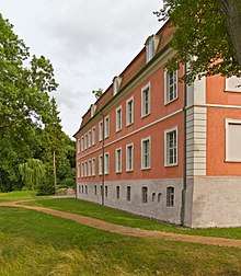
Wolfshagen manor
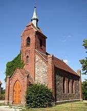
Church in Boddin
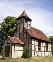
Church in Langnow
Groß Pankow (Prignitz) is a municipality in Prignitz district, Brandenburg, Germany. The municipality was formed in 2001 from the union of municipalities of the former Amt of Groß Pankow/Prignitz and some in Amt Pritzwalk-Land. Amt Groß Pankow/Prignitz was then dissolved.[2]
Groß Pankow is connected via German Federal Highway B 189 to the cities of Pritzwalk, Perleberg, Wittenberge and Magdeburg.
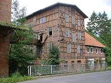
Former mill in Wolfshagen
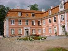
Wolfshagen manor
Geography
The municipality has 39 villages in 18 districts[3] with the populations given in parentheses (As of March 1, 2010)[4]
|
|
Demography
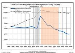 Development of population since 1875 within the current Boundaries (Blue Line: Population; Dotted Line: Comparison to Population development in Brandenburg state; Grey Background: Time of Nazi Germany; Red Background: Time of communist East Germany)
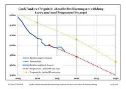 Recent Population Development and Projections (Population Development before Census 2011 (blue line); Recent Population Development according to the Census in Germany in 2011 (blue bordered line); Projection by the Brandenburg state for 2005-2030 (yellow line); Projection by the Brandenburg state for 2014-2030 (red line)
| Groß Pankow (Prignitz): Population development within the current boundaries (2017)[5] | ||||||||||||||||||||||||||||||||||||||||||||||||||||||||||||||||||||||||||||||||||||||||||||||||||||||||||||||||||||||||||||||||||||||
|---|---|---|---|---|---|---|---|---|---|---|---|---|---|---|---|---|---|---|---|---|---|---|---|---|---|---|---|---|---|---|---|---|---|---|---|---|---|---|---|---|---|---|---|---|---|---|---|---|---|---|---|---|---|---|---|---|---|---|---|---|---|---|---|---|---|---|---|---|---|---|---|---|---|---|---|---|---|---|---|---|---|---|---|---|---|---|---|---|---|---|---|---|---|---|---|---|---|---|---|---|---|---|---|---|---|---|---|---|---|---|---|---|---|---|---|---|---|---|---|---|---|---|---|---|---|---|---|---|---|---|---|---|---|---|
|
|
| ||||||||||||||||||||||||||||||||||||||||||||||||||||||||||||||||||||||||||||||||||||||||||||||||||||||||||||||||||||||||||||||||||||
Personalities
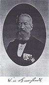
Carl von Karstedt
- Carl von Karstedt (1811-1888), conservative Reichstag deputy, born in Kleinlinde
- Erhard Hübener (1881-1958), DDP and LDPD politician, born in Tacken
- Richard Kackstein (1903-1966), national socialist politician, born in Triglitz
- Joachim Wüstenberg (1908-1993), hygienist in Gelsenkirchen, born in Klenzenhof
References
- ↑ "Bevölkerung im Land Brandenburg nach amtsfreien Gemeinden, Ämtern und Gemeinden 31. Dezember 2017 (Fortgeschriebene amtliche Einwohnerzahlen auf Grundlage des Zensus 2011)". Amt für Statistik Berlin-Brandenburg (in German). 2018.
- ↑ Amtsblatt für Brandenburg - Gemeinsames Ministerialblatt für das Land Brandenburg, 13. Jahrgang, Nummer 25, 19. Juni 2002, p.607 PDF Archived 2014-02-22 at the Wayback Machine..
- ↑ Hauptsatzung der Gemeinde Groß Pankow (Prignitz) vom 2. April 2009 PDF
- ↑ http://www.grosspankow.de/texte/seite.php?id=5998
- ↑ Detailed data sources are to be found in the Wikimedia Commons.Population Projection Brandenburg at Wikimedia Commons
Towns and municipalities in Prignitz | ||
|---|---|---|
This article is issued from
Wikipedia.
The text is licensed under Creative Commons - Attribution - Sharealike.
Additional terms may apply for the media files.