Greensboro Bend, Vermont
| Greensboro Bend, Vermont | |
|---|---|
| Census-designated place | |
 Greensboro Bend, Vermont | |
| Coordinates: 44°32′56″N 72°15′53″W / 44.54889°N 72.26472°WCoordinates: 44°32′56″N 72°15′53″W / 44.54889°N 72.26472°W | |
| Country | United States |
| State | Vermont |
| County | Orleans |
| Area[1] | |
| • Total | 2.228 sq mi (5.77 km2) |
| • Land | 2.210 sq mi (5.72 km2) |
| • Water | 0.018 sq mi (0.05 km2) |
| Elevation | 1,178 ft (359 m) |
| Population (2010)[2] | |
| • Total | 232 |
| • Density | 100/sq mi (40/km2) |
| Time zone | UTC-5 (Eastern (EST)) |
| • Summer (DST) | UTC-4 (EDT) |
| ZIP code | 05842[3] |
| Area code(s) | 802 |
| GNIS feature ID | 1457645[4] |
Greensboro Bend is a census-designated place in the town of Greensboro, Orleans County, Vermont, United States. Its population was 232 as of the 2010 census.[2]
References
- ↑ "US Gazetteer files: 2010, 2000, and 1990". United States Census Bureau. 2011-02-12. Retrieved 2011-04-23.
- 1 2 "American FactFinder". United States Census Bureau. Archived from the original on 2013-09-11. Retrieved 2011-05-14.
- ↑ United States Postal Service (2012). "USPS - Look Up a ZIP Code". Retrieved 2012-02-15.
- ↑ "Greensboro Bend". Geographic Names Information System. United States Geological Survey.
Municipalities and communities of Orleans County, Vermont, United States | ||
|---|---|---|
| City | 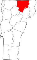 | |
| Towns | ||
| Villages | ||
| CDPs | ||
| Unincorporated communities | ||
This article is issued from
Wikipedia.
The text is licensed under Creative Commons - Attribution - Sharealike.
Additional terms may apply for the media files.