Green Jacket Shoal
| Green Jacket Shoal | |
|---|---|
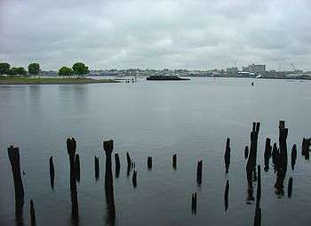 Green Jacket Shoal, viewed from India Point Park, facing Bold Point Park and the Providence River. | |
| Location |
Providence, Rhode Island East Providence, Rhode Island |
| Coordinates | 41°48′53″N 71°23′41″W / 41.81472°N 71.39472°W |
| Type | Shoal |
| Part of | Providence Harbor |
| Primary inflows | Providence River |
| Primary outflows | Seekonk River |
| Surface area | 33 acres (13 ha) |
Green Jacket Shoal is a 33-acre (13 ha) shoal and ship graveyard in Providence River, between the cities of East Providence and Providence, Rhode Island. It contains a large amount of debris from a century of abandoned and wrecked ships, destroyed docks, pilings, and other remnants of the area's industrial past. India Point, on the Providence side, was the city's first port, which remained active from 1680 until the Great Depression in the early 20th century. Bold Point, on the East Providence side, was home to a dry dock and other maritime businesses.
India Point and Bold Point were later turned into parks. Due to the dangers posed by the debris, as well as the changing character of the cities and increased public recreational use of the parks, a cleanup effort began in 2015 with federal, state, and non-governmental funding. An analysis of the shoal conducted prior to a cleanup found it to be Rhode Island's largest ship graveyard, with 29 separate vessels having accumulated over the years.
Geography
Green Jacket Shoal is a 33-acre area of the Providence River in Providence Harbor.[1] It sits between the Fox Point neighborhood of Providence on the north and northwest and the Riverside section of East Providence to the east and southeast. The Seekonk River, a tidal extension of the Providence River, continues to the northeast, and is flanked by India Point on the north side and Bold Point on the south side.
History
India Point, on the Providence side in the northeast part of the shoal, was Providence's first port, established in 1680.[2] It was a busy and prosperous waterfront area, taking its name from its trade connections with the East and West Indies.[2][3] Its success was in part due to the large trading businesses of John Brown and his partner, John Francis, who set up in Providence in 1787.[2] Brown, the namesake of Brown University, was active in the slave trade. He, his brother, his sons, and others in his family line brought slave ships to Providence as part of the Atlantic triangle trade.[4] In the late 1800s, the steamships that regularly came through the shoal to India Point carried immigrants to Rhode Island from Ireland, Cape Verde, the Azores, and Portugal.[3]
Bold Point, on the East Providence side of the shoal, was home to a dry dock, used to repair and maintain ships, as well as other maritime businesses.[5] According to The Providence Journal, from 1884-1919, Bold Point's Providence Dry Dock and Maine Railway Co. "was the main ship repair facility in Providence. Green Jacket Shoal was its parking lot."[5]
India Point remained profitable into the early 1900s, but began to decline during the Great Depression.[2] It was battered by the 1938 New England hurricane and commerce largely ceased. By the 1940s, it had turned into a scrap yard.[2] In the 1960s and 1970s, Providence underwent a concerted beautification effort, including the transformation of India Point into a park, which opened in 1974.[2]
The long period of neglect is still reflected in the condition of the shoal, which has accumulated a century's worth of debris. Remnants of destroyed docks, pilings, a dry dock, shipwrecks, abandoned ships, and other structures stick out of the water in many places around the shoal, owing to many years of natural disasters and economic hardship.[6][7][8]
As the character of the area moved away from its industrial past, and with increased public use of the water and its surroundings via India Point Park and Bold Point Park, the detritus has come to be a noted source of urban blight and significant safety concern for anyone using the water.[6][9]
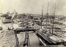
Ship graveyard
.jpeg)
Prior to a major 2015 cleanup effort, the Rhode Island Sea Grant funded a study of the debris in Green Jacket Shoal. In November 2015, marine archaeologist David Robinson of the University of Rhode Island counted 26 shipwrecks, making it the state's largest ship graveyard.[1] In 2018, he increased the number to 29 wrecks, supplementing his dives with help from local libraries and archives.[5]
Two of the ships are well known sidewheeler steamboats from the late 1800s and early 1900s: the Bay Queen and the Mount Hope, passenger boats measuring 182 feet and 193 feet, respectively.[10][11][8] Others are more recent, including a barge that is also the most visible wreck in the shoal.[5]
Robinson cites two reasons the site accumulated so many ships: "location and infrastructure".[8] While the shoal was shallow enough to be difficult for many ships to travel through, its place in the busy harbor made it a convenient place to dump unwanted ships. The shoal was also home to ship maintenance facilities, including area's main ship repair facility, the Providence Dry Dock and Maine Railway Co., making it easy to recover anything of value before they were discarded.[8] When the company closed in the early 20th century, the ships were left behind, floating near the coast of Bold Point.[5] The poor quality of the water in the polluted shoal may be responsible for the good conditions of the wrecks years later.[5]
Robinson describes the graveyard as not junk but "an archaeological site of some significance ... the last gasp of the merchant sailing fleet and the use of the bay as a playground for Rhode Islanders."[11]
According to Robinson via The Providence Journal, the graveyard contains six classes of ships: 2 sidewheeler cruise ships, 17 scow barges, 4 sailing ships, 3 harbor steamers, 2 steam/diesel boats, and 1 schooner barge.[5]
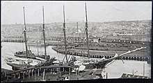
Cleanup
.jpg)
Clean Bays, a non-profit organization based in Middletown, Rhode Island, developed a technique for clearing underwater debris. It is based on the Aqualogger, a ship designed by Maine-based company Deadhead Lumber to recover valuable underwater timber.[12] Clean Bays modified the design by equipping it with an underwater chainsaw which can drop down to cut pieces of wood from larger structures.[12][6] By chopping up debris into smaller parts, it can be easier to bring them to shore, but importantly, it also does not dig up potentially harmful sediments like using more forceful pulling or dragging methods could.[12] The technique was piloted near Bold Point Park in summer 2014, with a grant from the Schmidt Family Foundation's 11th Hour Racing project.[13]
In 2015, Clean Bays removed two old barges from the shoal, and in 2014 and 2015, it received state and federal funding, through the National Oceanic and Atmospheric Administration, to pursue a year-long project to clean up not just Green Jacket Shoal but 350 acres of the Providence River and Seekonk River.[6][13][14] For the larger project, the organization modified its own ships to function like the Aqualogger, rather than make arrangements to use it again.[6] Some of the debris with historic value is planned to be left submerged.[11]
According to U.S. Senator Sheldon Whitehouse, who supported the project, "This is kind of an effort at reclaiming the Seekonk River and the northern tip of the Bay from long-gone industrial uses and making them appropriate for the kind of residential and recreational uses that could be a real gift to the cities if it were made a more appealing amenity."[12]
References
| Wikimedia Commons has media related to Green Jacket Shoal. |
- 1 2 "The Graveyard in Providence Harbor". Quadrangles Online. University of Rhode Island. 21 November 2015.
- 1 2 3 4 5 6 Betancourt, Frances (2 May 2002). "The Creation of India Point Park" (PDF). Friends of India Point Park. Archived from the original (PDF) on April 24, 2018. Retrieved July 27, 2018.
- 1 2 "About the Park". Friends of India Point Park. Retrieved July 27, 2018.
- ↑ Greene, Lorenzo Johnston. The Negro in colonial New England, 1620-1776. New York, New York: Columbia University Press.
- 1 2 3 4 5 6 7 Hill, John (June 13, 2018). "Off the coast of East Providence, an underwater graveyard". Providence Journal. Retrieved July 27, 2018.
- 1 2 3 4 5 Kuffner, Alex (26 November 2015). "Providence and Seekonk rivers due for a massive cleanup". Providence Journal.
- ↑ Comery, Beth (6 December 2015). "'Ship Graveyard' In Providence Harbor". Providence Daily Dose.
- 1 2 3 4 Haas, Meredith (11 July 2016). "One Man's Treasure : Uncovering Rhode Island's largest ship graveyard". 41°N Magazine. Rhode Island Sea Grant & The Coastal Institute at the University of Rhode Island.
- ↑ "CRMC permits Clean The Bay's debris removal project at Bold Point Park in EP". Rhode Island Coastal Resources Management Council. 17 February 2014.
- ↑ "URI Grad Robinson Discovers Ship Graveyard in Providence River". GoLocalProv. 6 March 2016.
- 1 2 3 "Below the Surface With Underwater Archaeologist Dave Robinson". Rhode Island Monthly. February 2016.
- 1 2 3 4 Salit, Richard (4 June 2014). "Test project begins to remove old timber from Seekonk River". Providence Journal.
- 1 2 Carini, Frank (16 June 2014). "Cutting Down Marine Relics to Open Up Bay". EcoRI.
- ↑ "East Providence gets grant to remove sunken barges". ABC 6 News. Associated Press. 30 September 2014.