Rhos Fawr
| Rhos Fawr | |
|---|---|
| Great Rhos | |
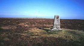 The summit plateau of Rhos Fawr | |
| Highest point | |
| Elevation | 660 m (2,170 ft) |
| Prominence | 374 m (1,227 ft) |
| Parent peak | Plynlimon |
| Listing | Marilyn, Hewitt, Nuttall, county top (Radnorshire) |
| Coordinates | 52°16′02″N 3°11′59″W / 52.2671°N 3.1998°W |
| Geography | |
| Location | Powys, Wales |
| Parent range | Cambrian Mountains |
| OS grid | SO182639 |
| Topo map | OS Landranger 148 |
| Listed summits of Rhos Fawr | ||||
| Name | Grid ref | Height | Status | |
|---|---|---|---|---|
| Black Mixen | SO196643 | 650 metres (2,133 ft) | Hewitt, Nuttall | |
| Bache Hill | SO213636 | 610 metres (2,001 ft) | Hewitt, Nuttall | |
| Whimble | SO205626 | 599 metres (1,965 ft) | Dewey | |
| Great Creigiau | SO198636 | 646 metres (2,119 ft) | Buxton & Lewis | |
Rhos Fawr or Great Rhos is a mountain summit in Mid Wales, and is the highest point on the Radnor Forest rock dome being 660 m or 2170 ft in height. The local rocks are sedimentary shales and mudstones with some Silurian limestone.
The summit is located on a broad heathery plateau, which is separated from Black Mixen: the eastern plateau summit, by the cwm of Harvey Dingle. To the west is Drygarn Fawr and Gorllwyn, to the north Plynlimon, to the east Black Mixen at 650 m or 2133 feet in height, and to the south the Black Mountains.[1] There is a prominent trig point at the summit, and a very useful landmark for walkers on the broad and featureless summit plateau.
References
External links
This article is issued from
Wikipedia.
The text is licensed under Creative Commons - Attribution - Sharealike.
Additional terms may apply for the media files.