Black Mixen
| Black Mixen | |
|---|---|
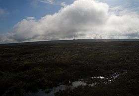 Black Mixen and the communications mast from the Rhos Fawr plateau | |
| Highest point | |
| Elevation | 650 m (2,130 ft) |
| Prominence | 45 m (148 ft) |
| Parent peak | Rhos Fawr |
| Listing | Hewitt, Nuttall, |
| Coordinates | 52°16′18″N 3°10′44″W / 52.2718°N 3.1789°WCoordinates: 52°16′18″N 3°10′44″W / 52.2718°N 3.1789°W |
| Geography | |
| Location | Powys, Wales |
| Parent range | Cambrian Mountains |
| OS grid | SO182639 |
| Topo map | OS Landranger 148 |
Black Mixen (Welsh: Y Domen Ddu) is a subsidiary summit of Rhos Fawr or Great Rhos in the Radnor Forest. The summit is large peat bog plateau. The summit is marked with a cairn, and is next to a radio transmitter and its building.[1]
Black Mixen is the only Nuttall to have a communications mast (a radio transmitter) on its summit.[2] To the east is Bache Hill, to the south are the Black Mountains, to the west is the Great Rhos plateau.
The summit cairn is probably of Bronze age date, with most peaks in the area showing similar barrowss.
References
- ↑ Nuttall, John & Anne (1999). The Mountains of England & Wales - Volume 1: Wales (2nd edition ed.). Milnthorpe, Cumbria: Cicerone. ISBN 1-85284-304-7.
- ↑ "Pumlumon". Archived from the original on 2002-05-08. Retrieved 2007-04-22.
External links
This article is issued from
Wikipedia.
The text is licensed under Creative Commons - Attribution - Sharealike.
Additional terms may apply for the media files.