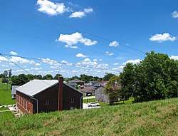
Gravel Switch, Kentucky
| Gravel Switch | |
|---|---|
| Unincorporated community | |
 Gravel Switch | |
 Gravel Switch Location within the state of Kentucky  Gravel Switch Gravel Switch (the US) | |
| Coordinates: 37°34′43″N 85°3′7″W / 37.57861°N 85.05194°WCoordinates: 37°34′43″N 85°3′7″W / 37.57861°N 85.05194°W | |
| Country | United States |
| State | Kentucky |
| County | Marion |
| Elevation | 909 ft (277 m) |
| Time zone | UTC-5 (Eastern (EST)) |
| • Summer (DST) | UTC-4 (EDT) |
| ZIP codes | 40328 |
| GNIS feature ID | 493182[1] |
Gravel Switch is an unincorporated community within Marion County, Kentucky, United States. It is located along Kentucky Route 243, just south of its intersection with U.S. Route 68, southwest of Perryville and northeast of Bradfordsville.
A post office was established in the community in 1870, and it was named for a valuable gravel deposit to which the local railroad directed a railway track.[2]
References
- ↑ U.S. Geological Survey Geographic Names Information System: Gravel Switch, Kentucky
- ↑ Rennick, Robert M. (1987). Kentucky Place Names. University Press of Kentucky. p. 123. ISBN 0813126312. Retrieved 2013-04-28.
External links

Municipalities and communities of Marion County, Kentucky, United States | ||
|---|---|---|
| Cities | 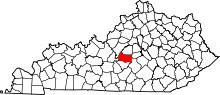 | |
| Unincorporated communities | ||
This article is issued from
Wikipedia.
The text is licensed under Creative Commons - Attribution - Sharealike.
Additional terms may apply for the media files.