Gratini
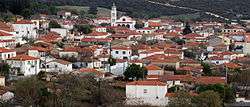
Gratini (Greek: Γρατινή) is a village of Rhodope regional unit in northern Greece, some 13 km north of Komotini.[1] It is part of the municipal unit of Komotini.[2]
History
The village first appears in the late Byzantine era, as the town of Gratzianous (η Γρατζιανούς), while Ottoman documents mention it as Iğrican and Ağricanhišar.[3] The late medieval village may possibly be identical to the ancient city of Gratianopolis, named after Emperor Gratian (r. 367–383), whose bishop is recorded as taking part in the First Council of Ephesus in 431.[3]
The town played a prominent role in the Byzantine civil wars of the mid-14th century. In 1344, during the war of 1341–1347, the well-fortified town was captured by John VI Kantakouzenos (r. 1341–1354), who appointed his son Matthew to rule over it and the surrounding province. Gratzianous remained the seat of Matthew and his family until 1355/56, when, after another civil war, he surrendered it and all his Thracian domains to John V Palaiologos (r. 1341–1391) in exchange for the Despotate of the Morea.[3]
Fortress
The ruins of the 14th-century fortress are preserved in a hill to the north of the modern village, near the river Patermos. The single wall is built using roughly hewn stone with mortar and brick fragments, as well as irregular brickwork. From north to south the fort has a span of over 250 feet, and features a tower on its eastern wall.[3][4] Amidst the ruins of the fortress lies a more recent chapel dedicated to the Life-giving Spring (Zoodochos Pigi)[5] next to which lies a large rectangular barrel vaulted cistern.[3][4]
 The fort of Gratini
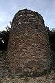 The eastern tower
 The chapel of the Life-giving Spring (Zoodochos Pigi)
Dam
1.5 km northwest of the village lies the Gratini Dam. With a height of 45 m and a capacity of 18 million cubic meters, it serves the nearby power plant of the Public Power Corporation.
People from Gratini
- Archbishop Chrysanthus of Athens (1881–1940)
References
| Wikimedia Commons has media related to Gratini. |
- ↑ Γρατινή (in Greek). Δικτυακή Πύλη Σημείων Ενδιαφέροντος Υπουργείου Μακεδονίας - Θράκης. Retrieved 2012-09-29.
- ↑ Kallikratis law Greece Ministry of Interior (in Greek)
- 1 2 3 4 5 Soustal, Peter (1991). Tabula Imperii Byzantini, Band 6: Thrakien (Thrakē, Rodopē und Haimimontos) (in German). Vienna: Verlag der Österreichischen Akademie der Wissenschaften. pp. 276–277. ISBN 3-7001-1898-8.
- 1 2 Aikaterini Balla (2007-11-28). Κάστρο Γρατινής (in Greek). Regional guide of E. Macedonia & Thrace. Retrieved 2011-02-09.
- ↑ Η Γρατινή φόρεσε τα καλά της για τη Ζωοδόχο Πηγή (in Greek). Ο Χρόνος. 2012-09-29. Retrieved 2012-02-10.